10128 Caoba Street is a delightful 1 story single family home located in the Siena Oaks neighborhood in Palm Beach Gardens, Florida. This home is tastefully renovated with a new roof, newer air conditioning, new tile flooring, updated kitchen and bathrooms. The home has 3 bedrooms, 2 bathrooms, a 2 car garage and a very spacious fenced back yard. Siena Oaks in conveniently located in central Palm Beach Gardens, a short drive to the Gardens Mall, the beach, golf courses, I95 and the Florida Turnpike. The community has a community swimming pool, lighted tennis courts and low HOA fees.
Earman River, riparian rights and the North Palm Beach Canals
What is going on with the houses in North Palm Beach along the C-17, a/k/a “Earman River“, and the ownership of the canals in North Palm Beach in general?
There was an article in the Palm Beach Post a few months ago about the Earman River so I decided to look into it a bit today. Basically, when the Village of North Palm Beach was first developed by a guy named John (Jack) Schwencke and others the first plat (Plat 1) was of land bordering on the C-17 canal from Anchorage Park to the Route 1 bridge and south of Lighthouse Drive. The C-17 canal on this plat was shown as the “Earman River” with an irregular shore line (a “meander line“) as a true riparian line would be shown on a plat IF it were a river. The problem is that the land below the C-17 canal west of US-1 was not navigable when the state was created. The actual meander line is east of the Rt 1 bridge. Thus this waterway is “overflowed lands” and thus is not “navigable” water by statutory definition. Thus, the land owners abutting these “overflowed lands”) do not enjoy statutory riparian rights. So who owns the land below that water in the C-17 canal?
The Palm Beach historcial society gives this information on the history of “Dimick’s Ditch” or the “Earman River”.
Property ownership rights are a pretty straight forward thing 95% of the time. You own what you own unless and until you convey it it’s taken away from you. Back in 1955 Bankers Life & Casualty Company (John D MacArthur) sold some land it owned (which the state did not) to another corporation, North Palm Beach Inc.
In 1956 the new owner (North Palm Beach Inc.) began the process of subdividing the land to sell it off. This was done in stages and the first stage was Plat 1. This was the move that gave rise to the Village of North Palm Beach.
Plat 1 shows house lots (which were later sold), drainage easements (restrictions on some lots for the benefit of all), public rights of way (streets) which were “dedicated” to the public. It shows the lots along the C-17 as being along the “Earman River”. And includes detaisl that would indicate that they believed it to be a river such as: (1) the legal description of the lands contained on the plat runs down the centerline of the “Earman River” (2) It’s a named body of water. (3) It has an irregular shoreline, a “meander line”. (4) showed the uplands lots adjacent to it as having lot lines that intersect the “meander line”. And (5) showes those side lot lines as having +/- dimensions. You see, the “meander line” is said to be “ambulatory”. It can and does move so long as that movement is “slow and imperceptible”. When the meander line moves the lot can get larger or smaller through the processes of acrretion and reliction. All of this would lead me to believe that the developer believed, and represented to Buyers, that the Earman River was in fact a river and it was navigable when the State of Florida was created and that the state owned the land below that water and that the upland abutters enjoyed riparian rights.
Plat 1 also showed what are clearly man made waterways as these have exact dimensions and straight lines like the main “North Palm Beach Waterway” to the west of Anchorage Park and side canals labeled as the “Coral Lagoon” , “Blue Lagoon” and “Azure Lagoon”. The plat, on its’ face, dedicates things like the streets to the public AND it specifically reserves unto the grantor the land below the waterways and lagoons shown on that plat. BUT it does not say anything about the area labeled as the “Earman River”. Another indication that they believed it to be “Sovereign Submerged Lands”
So these waterways were not conveyed on the Plat. HOWEVER, at the first meeting of the Village Council of the newly formed municipality of North Palm Beach the canals shown on the plat (but no mention of the lands below the Earman river) are offered to, and accepted by, the municipality as a dedication with certain obligations and use restrictions.
Note that these accepted conditions and restrictions on use are referred to for subsequent recorded plats. They became the standard for most BUT not all canals in the Village.
OK, so now the public has the roads shown on Plat 1 and the Village has the waterways and the developer owns everything else within the legal description of the boundary of the plat.
This is a key part to the story, as I see it. The developer, who still owned everything shown on Plat 1, conveyed via a recorded document, to the predecessor to the South Florida Water Management district the “the perpetual easement AND the right for and to the exclusive use and enjoyment of the following described lands”
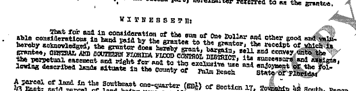
And the legal description of this goes well LANDWARD of the meander line shown on Plat 1. The devoper still owned all the lots on Plat 1 and it lokos like this was to “fix” the mistake made on Plat 1. Plat 2 shows this easement in nice straight lines.
Then, AFTER THE ‘EASEMENT IS RECORDED’ they start selling off lots. They sell those lots on Plat 1, the economy is booming so they record a few more plats to sell some more houses.
The point of contention here is that since North Palm Beach Inc. never outright sold the over flowed land below the C-17 / “Earman River” then that entity still owns it. Or does it?
In Florida if one grants an easement then that person still holds the majority of the beneficial interest in the title to the land, and pay the taxes on it. The easment is a restriction on the use and enjoyment of the lands encumbered bu it. But if one transfers to another the “exclusive use and enjoyment” of the land on a conveyance labeled as an easement then can they then come bac later on and attempt to convey that? What was reminaing the proverbial bundle of rights that were not conveyed?
It is worth noting here that this land was removed from the tax roll as government entities (like the SFWMD) do not pay taxes on their land. Was that a mistake?
Now, after all the development was completed, and the developer was closing out the business venture of developing North Palm Beach, they transferred all their interests in all lands they owned and HAD NOT PREVIOULSY DISPOSED OF to a new entity. This was done into the entity “Pinner”. At that time NPB Properties Inc. was developing other areas around us like Cabana Colony.
BTW, this issue was well known to be “an issue” back in the 1970’s. Heck, ALL the plats AFTER Plat 1 do NOT show the “Earman River” with an irregular shore line they show the C-17 Canal with exact dimensions. Someone picked up on this mistake pretty much right away. Plat 2 was recorded 9 July 1957…
Now, Plat 2 shows houses along Kittyhawk, Jaybird and Ibis Way and it shows the area we’re calling the Earman River but it is labeled as the “C-17 Canal”. The legal description of the plat runs down the centerline of the C-17 Canal easement. It also shows 3 Lagoons being Azure, Blue and Coral on the west side of the NPB Waterway and that plat dedicates the Lagoons (which would not include the land below the C-17 canal) to the Village subject to a document recorded in Official Record Book 6 Page 393. This is the conditions of the dedication to the Village noted above that occured at the first Village council meeting. Note here that the North Palm Beach Waterway is shown on Plat 1 so no need to mention that on Plat 2. Note also that the ‘waterfront’ lots shown on this and subsequent plats are show as having exact side dimensions right up to the line of the C-17 Canal. What about those dashed lines?
The contention of some is that those dashed lines shown on subsequent plats may MAY have been intended to show what are called reversion lines indicative of a reversionary interest in the land below the C-17. IN the event that the easement were to be release then the adjacent then the interest in the C-17 would revert to the adjacent lot. But, IMHO, one can not have a reversionary interest in a drainage easement because these do not have any reversionary interest granted to an abutter which would revert back. Also, if a full conveyance was never made and it was “just an easement” then all that this entity releases it would have to release is an easement. Again, just IMHO. Also, solid lines typically show property lines.


Plat 5 shows the south side of the C-17 Canal on the opposite side of the water from Plat 1. Plat 6 shows what WAS labeled the “Earman River” on Plat 1 as the C-17 Canal. The legal description of this plat goes to the centerline of the C-17 Canal and this plat DOES NOT SAY ANYTHING about any dedication of any waterways or lagoons.
So that’s the landscape and I apologize as there is no short version of this story. Now let’s fast forward to about 10 years ago. Jack dies and his heirs inherir his interest in North Palm Beach Properties Inc. There’s some money to be made in this detail and they decide they want it. And, they have been sending letters and selling this disputed submerged land to the uplands abutters and if they don’t pay then they get a cease and desist from using the land. There have been number of law suits and some have been settled such as the one with Paradise Villas Condominium But that was on the east ide of US-1
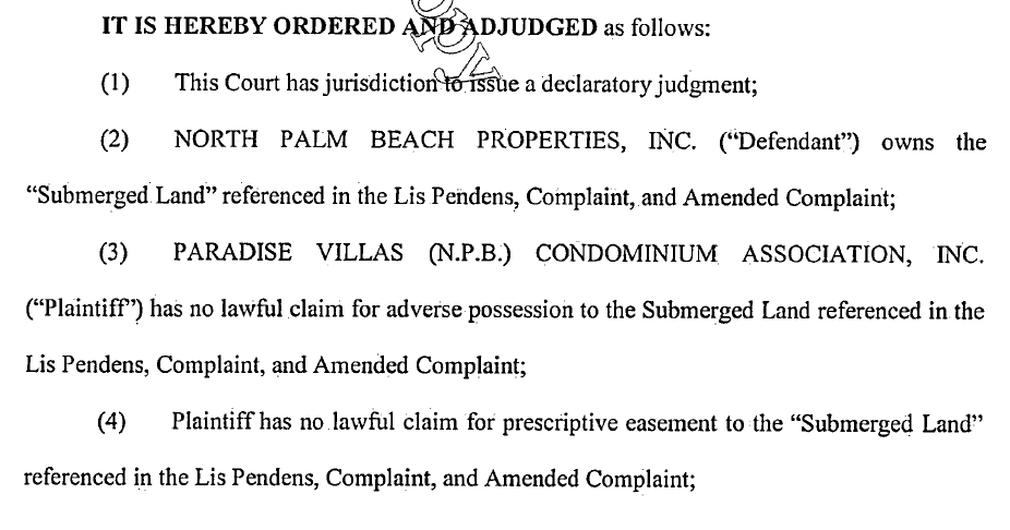
Some would say that’s the ball game. Get your check book out if you own a ‘waterfront’ parcel shown on what you thought was the “Earman River”. Some lawyers and property owners are still trying to dispute this and we’ll see if they are successful or not. It has been pointed out to me that this case has yet to be heard by a judge and and that the above excerpt is not a judgement entered by a judge but rather stipulations agreed to by the parties.
Other plats recorded such as Plat 6 for the houses around Lagoon and Waterway Drive specifically dedicates the area on the plat shown as ‘Lagoon, Lake or Waterway’ to the Village of North Palm Beach subject to this same document recorded in Official Record Book 6 Page 393. This would be the westerly half main waterway beginning on the north side of the Lighthouse Bridge. The POB on this plat looks to be wrong. It states that it starts at the intersection of the centerline of the NBP Waterway with the centerline of Lighthouse drive as show on the adjacent plat but NO SUCH point is shown on the plat. The legal description on this plat does clearly run down the centerline of the NPB Waterway. The issue is that the legal description for the Golf Course Addition No 1 and No 2 ONLY go to the bulkhead line on the east side of the waterway and are silent on any use of the adjacent waterway by the uplands abutters.
The Country Club Addition Plat for the houses on Pilot, Riverside and Shore Roads also uses the same language of Plat 6 dedicating the land below the Lagoons and Waterways to the Village subject to this same document recorded in Official Record Book 6 Page 393. This plat extends to the west side of the North Palm Beach Waterway.
The Golf Course Addition for the houses along Country Club Drive north of Shore Rd does not say ANYTHING about the waterway. It shows the “North Palm Beach Waterway” on the plat but the legal description does not cover anything past the bulkheads. And it is silent on the use of the adjacent waterway by the uplands abutters.
The Country Club Addition Number 2 for the houses at the very end of Country Club Drive and also does not say ANYTHING about the waterway. It does show the “North Palm Beach Waterway” on the plat but again the legal description does not cover anything past the the approximate sea wall. And it too is silent on the use of the adjacent waterway by the uplands abutters.
I thought the above is a problem for years for a few reasons. The first being that the legal description of Plat 6 on the west side of the main waterway only goes to the centerline of the North Palm Beach Waterway and only up to just inside of the current Harbour Isles basically. The plats on the east side of the main waterway (Golf Course Addition 1 & 2) only goes to the sea wall line. In short, there’s a gap being the east 1/2 of the “North Palm Beach Waterway” from Half Moon Lagoon to the north end of Plat 6 and perhaps the full width of the canal from the end of Plat 6 to the intracoastal.
And then I recently discovered the mssing link in this “hole”. The NPB Waterway in this are was not dedicated on the face of a plat as others were. It was dedicated via a recorded document ORB 644 Page 269…
And how about the canals east of US-1 over by Frigates like the C-17, the canals with the condos around them south of it and houses behind the police station along Bowsprit, Davit & Ebbtide? This is super interesting. This land was in the first bulk sale from MacArthur to North Palm Beach Inc. who a few years later sold it back to MacArthur. MacArthur then records
Which shows the C-17 labeled as a canal as the others are and dedicates them on the face of the plat “to the perpetual use of the public, as public highways and waterways, the streets and canals as shown hereon”…

Now when a street is dedicated ot he public, that’s everyone. Again, seems straight forward to me that Frigates, the condos, Nautical Ventures and the rest of the folks on the C-17 east of US-1 should not have paid a nickel to use the C-17.
The houses on Davit and Ebbtide were actually part of re-plat. MacArthur solf that area to American Realty who reverted the plat and then re-plat’d it and they dedicated the canals to the perpetual use of the public for “proper” purposes.
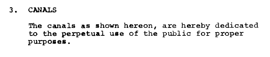
So yet a different verbiage again. What a hot mess and nothing that would seem to allow the uplands abutter any more right to build a dock than any other member of the public. This plat only goes to the half way point (+/-) of the canal that separates this community from the Yacht Club Addition, where I live, and that plat (Yacht Club Addition) uses the same language as the others plats referencing the document in Official Record Book 6 Page 393. So, Half of the canal is for “proper public use” and the other half is subject to the usual NPB use restrictions.
Part of this area is the intracoastal waterway.
If you’re still reading this then you can see that ownership of waterfront property can be VERY tricky. If you want buy or sell your property with someone who knows all about these things then call me, Chris Ryder at 561.626.8550.
Juno Beach Octoberfest 2019
The 2019 Juno Beach Octoberfest will be held on Friday the 25th of October from 5-8 PM at The town hall.

Escrow Contrast: Buyer Obligation vs. Broker Responsibility
In the FR/Bar contract, a buyer, by default, has three days to deposit their escrow, and a broker has three days at most to deposit that escrow. But if the broker isn’t the escrow agent, the timing calculations are different – and confusing to some Realtors.
Source: Escrow Contrast: Buyer Obligation vs. Broker Responsibility
NEWS & MEDIA
illustration of buyer and seller
sorbetto / getty images
OCTOBER 2, 2019Share this article: FacebookTwitterLinkedInShare
Escrow Contrast: Buyer Obligation vs. Broker Responsibility
By Laura Gomes
In the FR/Bar contract, a buyer, by default, has three days to deposit their escrow, and a broker has three days at most to deposit that escrow. But if the broker isn’t the escrow agent, the timing calculations are different – and confusing to some Realtors.
ORLANDO, Fla. – Purchasing a home is one of the largest financial decisions anyone can make, and escrow deposits are usually involved. Escrow deposit questions are also one of the most frequent topics we get on Florida Realtors® Legal Hotline, and justifiably so.
However, there is a crucial difference between buyers’ obligation and brokers’ responsibility when it comes to escrow deposits – and knowing the difference is important.
It’s vital to adhere to licensing law when you’re acting as an agent in a transaction. It is just as imperative for buyers to adhere to the terms of their sales contract. Sometimes, however, terms overlap and can cause confusion over an obligation under licensing law versus a contractual obligation. Remember, buyers’ legal obligation is to the contract terms and brokers’ obligation is to licensing law. The two are separate matters that should not be confused.
Here is the mix-up we hear on the Legal Hotline: Because the contract often states that a buyer’s deposit is due within three days as the default time period and brokers’ licensing law refers to a three day period regarding escrow deposits, the two obligations often get intertwined. That leads to questions about who is supposed to be doing what when.
Let’s explore what I mean.
Buyers obligation under the contract
The Florida Realtors/Florida Bar Contracts (FR/Bar) contains language within paragraph 2(a) that states “The initial deposit made payable and delivered to the ‘escrow agent’ named below … is to be made within ___ (if left blank, then 3) days after Effective Date.”
Assuming the parties leave the time period blank, which is often the case, buyers have three days to deposit their escrow. To determine how buyers should count those three days, buyers should look to the contract. Remember, time can be calculated differently in each contract so, it’s important to note that in figuring out when a deposit is due.
As we’re using the FR/Bar contracts in our example, calendar days are used for purposes of computing time. T Therefore, this contract obligates buyers to make their escrow deposit within three calendar days after the Effective Date.
Associate and broker responsibility under licensing law
A rule commonly referenced by agents and brokers has to do with depositing escrow funds.
61J2-14.009 of the Florida Administrative Code (FAC) states that every associate who receives any deposit shall deliver that deposit to the broker “no later than the end of the next business day following receipt of the item to be deposited.” Saturday, Sundays and legal holidays are not considered business days.
61J2-14.010 of the FAC clarifies that the broker has to place the deposit “immediately” where it is designated to go. Usually this is either in the broker’s own escrow account or with a title company. “Immediately” is defined under 61J2-14.008(3) as “no later than the end of the third business day following receipt.” Receipt by a sales associate or any other representative of the brokerage constitutes receipt by the broker for the purpose of placing the deposit immediately.
What does all of this mean? If the brokerage – meaning an associate, broker or representative of the brokerage – receives any deposit, that deposit must be where it needs to be no later than the end of the third business day after it’s received.
What happens when buyers give the escrow deposit to an agent or broker?
Using the above examples of the buyers having three calendar days to place their deposit with the escrow agent, and brokers needing to get any deposit they receive to the escrow agent no later than the end of the third business day following receipt, what happens when the buyers give their deposit, let’s say a check, to the agent?
This is where it can get tricky. A lot depends on who the escrow agent is.
If the escrow agent is the broker, then by delivering the check to the broker within three calendar days, the buyers have complied with their obligation under the contract. The broker then needs to deposit that into the brokerage escrow account no later than the end of the third business day to comply with their licensing law requirement.
But what if the escrow agent is a title company or attorney? This is where the agent must be aware of both the contract and licensing law timeframes. Let’s take a look at an example of what I mean.
Let’s say the buyers deposit is due within three calendar days after the Effective Date to ABC Title Company per the contract. The buyers deliver a check to their broker on calendar day two. Based on the rule discussed above, the broker has up to three business days to get it to ABC Title Co. However, if the broker complies with this rule and delivers the check to ABC Title Co on business day three, the buyers’ deposit isn’t being delivered to the escrow agent until after the buyers’ deadline in the contract.
Paragraph 15(a) of the FR/Bar contracts discusses Buyers Default, which includes buyers failing, neglecting or refusing to perform their obligations under the contract, including payment of the deposit.
Escrow Agent information is provided in the FR/Bar contracts under Paragraph 2(a) so that buyers know who must receive the deposit. A conservative recommendation for brokers: If they’re not the Escrow Agent listed in the contract, direct buyers to provide the deposit directly to the Escrow Agent by the deadline. This would eliminate any possible risk or liability that would come with a potential conflict between buyers’ obligations under the contract and brokers’ responsibilities under their licensing law.
However, if a broker is willing to take a buyer’s deposit when the broker is not the Escrow Agent, that broker should be well aware of that buyer’s deadline under the contract to ensure they’re not putting the buyer’s contract at risk due to a late deposit.
Laura Gomes is a Florida Realtors Legal Hotline attorney
© 2019 Florida Realtors®
11312 Glen Oaks Court, Twelve Oaks
If you don’t want to live in a condo building, but want the convenience of no maintenance that comes with a condo, this property is for you. 11312 Glen Oaks Court is a charming 2-story villa that has all the conveniences of a condo. Although you live in an updated 3 bedroom, 2.5 bathroom, 1 car garage unit, all exterior maintenance including roof, exterior paint and landscaping is handled by the Twelve Oaks Association. This delightful waterfront neighborhood is conveniently located just east on PGA Blvd after US1. Walk across to Oakbrook Plaza, Publix, Duffys, Starbucks, Steinmart and many other restaurants and stores. Twelve Oaks has a manned gate, multiple community pools, a clubhouse, tennis courts and a marina. Call R&R Realty to schedule a viewing.
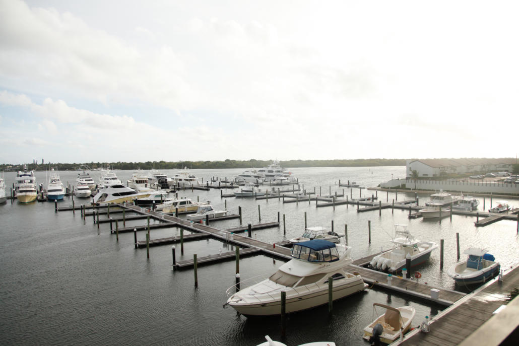
10 Questions to ask when buying a waterfront house in Florida.
What 10 Questions to ask when buying a waterfront house in Florida.
- Who owns the land below the water? Was the water “navigable” when Florida entered the Union? Does the lot enjoy “riparian” rights? There are 2 basic types of land below water in Florida, land owned by the state and subject to “navigational servitude” and over flowed land owned by sometimes the state but most of the time someone else. Here’s an example for a property on the St. Lucie River.
- If the land below the water is NOT owned by the State of Florida then who does own it? What rights have they conferred upon uplands abutters and what, if any, restrictions have they placed upon them and the use of the water column above the “over flowed” land they own?
- If the land below the water is not owned by the state is there an easement recorded in the public record, or some other right, for the benefit of the subject property to pass over the submerged lands of others until one reaches “navigable” waters where as part on the ‘navigational servitude’ the general public enjoys “rights of navigation”? It’s nott just where your dock is. You need a path to the waterway out to where the general public enjoys “rights of navigation”.
- If the land below the water is not owned by the State of of Florida then who maintains the canal? The municipality? The HOA? Or, is there a canal maintenance agreement recorded that provides triggers and apportion of expenses to the uplands lot owners, pperhaps through an HAO.
- When was the sea wall constructed? Is it on the bulkhead line, if applicable, or on or past the lot line?
- How wide is the canal from sea wall to lot line to lot line, sea wall to sea wall or dock to dock?
- How far into the canal can one go with a dock? Or with a boat? Or with dolphin or tie off piles?
- Can I aplce a lift in the dock and are there any limits as to how many, or what kind of, boats I may keep there?
- What is the flood zone designation of the house on the lot and is there a benchmark for an elevation someplace?
- When was the dock constructed? And, is EVERYTHING about the dock, and sea wall, properly permitted?
The above are technical and require some thought. If you’re looking for a Broker who has “done their homework”. Some other basic questions to ask afte r those above are:
- Are there any shallow spots between this property and the open water?
- Are there slow speed zones between the property and open water?
- Is there a path to the open water that does not require one go under a fixed bridge
- What are the closed bridge heights between the property and open water? Jupter area bridge clearances.
- Is the property on city sewer or on-site septic. There’s a push right now, for good reason, to get waterfront parcels onto city sewer and if this happens it will cost you $$$.
- When was the sea wall constructed? Obvious but the sea wall has a life span just like a roof. If it needs to be replaced does it need to be a particular material, like concrete? Can it be moved further out into the waterway?
- How wide is the canal? Again, an obvious question but ask it to know if the uplands contiguous with the property you’re interested in are part of the property or inside of the supposed canal.
- How far into the canal can one go with a dock? Or with a boat? A typical answer is 1/3 but it may be 1/4 or even less.
- What is the flood zone designation of the house on the lot and is there a benchmark for the elevation someplace? If your buying something on the water then the flood zone is a MAJOR factor. Most places have a base flood elevation or BFE that is set on the FEMA maps. This affects the ability to finance and potentially rebuild in the event of a flood loss and MUCH MUCH more.
- Who owns the land below the water? Is it riparian or littoral rights water? It it’s riparian then you have the right to get out to ‘navigable’ water with your dock but the state of Florida owns the land below the water. If it’s littoral then someone (you, an association or even a municipality) owns the land under the water.
- Who maintains the land below the water? If you think building a new sea wall is expensive then try dredging out that walerway and disposing of all the spoils. Who’s paying for that?
- Are there any shallow spots between this property and the open water? If you’re really interested in a property then BEFORE you own it make a ‘dry run’ from the dock to wherever and do so at low tide. You’d hate to buy a place and then find out there’s a ‘hump’ at the end of the canal that you can’t get past.
- Is there a path to the open water that does not require one go under a fixed bridge? You may not own a sailboat but think like you do, they buy property too.
- What are the closed bridge heights between the property and open water? In a hurricane the bridges get ‘locked down’ or remain in the closed position. Also, life is allot easier if one does not have to sit around waiting on bridges to open.
- Is there a limit on the number of boats I can store here or the type of boat I can have here? Some municipalities and associations limit these. They also can be limited by the DEP permit which may say something like only 1 motorized vessel per lot and a jet ski counts.
There are allot more questions that I would ask but starting with these will lead into conversations that should answer 90% of the concerns.
- « Previous Page
- 1
- …
- 101
- 102
- 103
- 104
- 105
- …
- 181
- Next Page »


