• Home Search
    • Save a Search
      • WP Realty Register
      • WP Realty Account
    • Residential
    • Map Search
    • Homes Coming Soon to the Market
    • Jupiter FL New Listings
    • Palm Beach Gardens FL New Listings
    • Juno Beach FL New Listings
    • North Palm Beach FL New Listings
    • Tequesta FL New Listings
    • Jupiter Island FL New Listings
    • Singer Island FL New Listings
  • Maps
    • Jupiter Neighborhoods
    • Palm Beach Gardens Neighborhoods
    • Juno Beach Neighborhoods
    • Jupiter Island Neighborhoods
    • Singer Island Neighborhoods
    • Abacoa Neighborhoods
    • PGA National MAP
  • Browse by City
    • Golf Homes
    • Jupiter
    • Palm Beach Gardens
    • Juno Beach
    • North Palm Beach
    • Singer Island
    • Jupiter Island
    • Tequesta
    • All Listings
  • Buying
    • Overview
    • Private Clients
      • Why Do This?
      • Create Private Client Gateway
      • Access Your Private Client Gateway
    • Get Ready!!!
    • Foreign Buyers
    • Financing
    • Home Search
    • Short Sales & REO’s
    • Make an Offer
    • Under Contract
    • Close
    • Buyer’s Tool Box
    • 55 Plus Communities
    • Northern Palm Beach County School District Homes for Sale
    • Northern Palm Beach County Flood Information
  • Selling
    • Selling Your Home in Palm Beach
    • Short Sales for Sellers
    • Foreclosures for Sellers
  • About
    • Our Agents
    • Contact Us
  • FB
  • Twitter
  • Call (561)626-8550

R&R Realty - Jupiter Real Estate

Find Jupiter-Palm Beach Gardens-Juno Beach-Singer Island-Jupiter Island property.

Earman River, riparian rights and the North Palm Beach Canals

October 9, 2019 by Chris Ryder

What is going on with the houses in North Palm Beach along the C-17, a/k/a “Earman River“, and the ownership of the canals in North Palm Beach in general?

There was an article in the Palm Beach Post a few months ago about the Earman River so I decided to look into it a bit today. Basically, when the Village of North Palm Beach was first developed by a guy named John (Jack) Schwencke and others the first plat (Plat 1) was of land bordering on the C-17 canal from Anchorage Park to the Route 1 bridge and south of Lighthouse Drive. The C-17 canal on this plat was shown as the “Earman River” with an irregular shore line (a “meander line“) as a true riparian line would be shown on a plat IF it were a river. The problem is that the land below the C-17 canal west of US-1 was not navigable when the state was created. The actual meander line is east of the Rt 1 bridge. Thus this waterway is “overflowed lands” and thus is not “navigable” water by statutory definition. Thus, the land owners abutting these “overflowed lands”) do not enjoy statutory riparian rights. So who owns the land below that water in the C-17 canal?

The Palm Beach historcial society gives this information on the history of “Dimick’s Ditch” or the “Earman River”.

Property ownership rights are a pretty straight forward thing 95% of the time. You own what you own unless and until you convey it it’s taken away from you. Back in 1955 Bankers Life & Casualty Company (John D MacArthur) sold some land it owned (which the state did not) to another corporation, North Palm Beach Inc.

SP-Search-Package-3Download

In 1956 the new owner (North Palm Beach Inc.) began the process of subdividing the land to sell it off. This was done in stages and the first stage was Plat 1. This was the move that gave rise to the Village of North Palm Beach.

Plat_Book_24_Page_202_Plat_1Download

Plat 1 shows house lots (which were later sold), drainage easements (restrictions on some lots for the benefit of all), public rights of way (streets) which were “dedicated” to the public. It shows the lots along the C-17 as being along the “Earman River”. And includes detaisl that would indicate that they believed it to be a river such as: (1) the legal description of the lands contained on the plat runs down the centerline of the “Earman River” (2) It’s a named body of water. (3) It has an irregular shoreline, a “meander line”. (4) showed the uplands lots adjacent to it as having lot lines that intersect the “meander line”. And (5) showes those side lot lines as having +/- dimensions. You see, the “meander line” is said to be “ambulatory”. It can and does move so long as that movement is “slow and imperceptible”. When the meander line moves the lot can get larger or smaller through the processes of acrretion and reliction. All of this would lead me to believe that the developer believed, and represented to Buyers, that the Earman River was in fact a river and it was navigable when the State of Florida was created and that the state owned the land below that water and that the upland abutters enjoyed riparian rights.

Plat 1 also showed what are clearly man made waterways as these have exact dimensions and straight lines like the main “North Palm Beach Waterway” to the west of Anchorage Park and side canals labeled as the “Coral Lagoon” , “Blue Lagoon” and “Azure Lagoon”. The plat, on its’ face, dedicates things like the streets to the public AND it specifically reserves unto the grantor the land below the waterways and lagoons shown on that plat. BUT it does not say anything about the area labeled as the “Earman River”. Another indication that they believed it to be “Sovereign Submerged Lands”

So these waterways were not conveyed on the Plat. HOWEVER, at the first meeting of the Village Council of the newly formed municipality of North Palm Beach the canals shown on the plat (but no mention of the lands below the Earman river) are offered to, and accepted by, the municipality as a dedication with certain obligations and use restrictions.

Offer-to-Dedicate-Canals-Plat-1Download

Note that these accepted conditions and restrictions on use are referred to for subsequent recorded plats. They became the standard for most BUT not all canals in the Village.

1957-10-Accepting-Offer-of-Dedication_Plat-1-CanalsDownload
BK_6_PG_393Download
BK_6_PG_396Download

OK, so now the public has the roads shown on Plat 1 and the Village has the waterways and the developer owns everything else within the legal description of the boundary of the plat.

This is a key part to the story, as I see it. The developer, who still owned everything shown on Plat 1, conveyed via a recorded document, to the predecessor to the South Florida Water Management district the “the perpetual easement AND the right for and to the exclusive use and enjoyment of the following described lands”

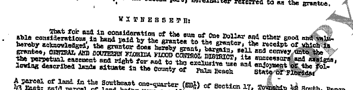
And the legal description of this goes well LANDWARD of the meander line shown on Plat 1. The devoper still owned all the lots on Plat 1 and it lokos like this was to “fix” the mistake made on Plat 1. Plat 2 shows this easement in nice straight lines.

Then, AFTER THE ‘EASEMENT IS RECORDED’ they start selling off lots. They sell those lots on Plat 1, the economy is booming so they record a few more plats to sell some more houses.

The point of contention here is that since North Palm Beach Inc. never outright sold the over flowed land below the C-17 / “Earman River” then that entity still owns it. Or does it?

In Florida if one grants an easement then that person still holds the majority of the beneficial interest in the title to the land, and pay the taxes on it. The easment is a restriction on the use and enjoyment of the lands encumbered bu it. But if one transfers to another the “exclusive use and enjoyment” of the land on a conveyance labeled as an easement then can they then come bac later on and attempt to convey that? What was reminaing the proverbial bundle of rights that were not conveyed?

It is worth noting here that this land was removed from the tax roll as government entities (like the SFWMD) do not pay taxes on their land. Was that a mistake?

Now, after all the development was completed, and the developer was closing out the business venture of developing North Palm Beach, they transferred all their interests in all lands they owned and HAD NOT PREVIOULSY DISPOSED OF to a new entity. This was done into the entity “Pinner”.  At that time NPB Properties Inc. was developing other areas around us like Cabana Colony.

BTW, this issue was well known to be “an issue” back in the 1970’s. Heck, ALL the plats AFTER Plat 1 do NOT show the “Earman River” with an irregular shore line they show the C-17 Canal with exact dimensions. Someone picked up on this mistake pretty much right away. Plat 2 was recorded 9 July 1957…

Plat_Book_25_Page_59_Plat_2Download
1957-26-Resolution-Accepting-Offer-of-Dedication-Plat-2-CanalsDownload

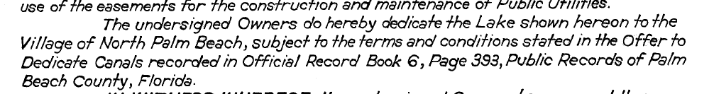
Now, Plat 2 shows houses along Kittyhawk, Jaybird and Ibis Way and it shows the area we’re calling the Earman River but it is labeled as the “C-17 Canal”. The legal description of the plat runs down the centerline of the C-17 Canal easement. It also shows 3 Lagoons being Azure, Blue and Coral on the west side of the NPB Waterway and that plat dedicates the Lagoons (which would not include the land below the C-17 canal) to the Village subject to a document recorded in Official Record Book 6 Page 393. This is the conditions of the dedication to the Village noted above that occured at the first Village council meeting. Note here that the North Palm Beach Waterway is shown on Plat 1 so no need to mention that on Plat 2. Note also that the ‘waterfront’ lots shown on this and subsequent plats are show as having exact side dimensions right up to the line of the C-17 Canal. What about those dashed lines?

The contention of some is that those dashed lines shown on subsequent plats may MAY have been intended to show what are called reversion lines indicative of a reversionary interest in the land below the C-17. IN the event that the easement were to be release then the adjacent then the interest in the C-17 would revert to the adjacent lot. But, IMHO, one can not have a reversionary interest in a drainage easement because these do not have any reversionary interest granted to an abutter which would revert back. Also, if a full conveyance was never made and it was “just an easement” then all that this entity releases it would have to release is an easement. Again, just IMHO. Also, solid lines typically show property lines.

Plat_Book_25_Page_175_Plat_3Download
Resolution-47-Offer-to-Dedicate-CanalsDownload

Plat_Book_25_Page_6_Plat_5Download

Plat 5 shows the south side of the C-17 Canal on the opposite side of the water from Plat 1. Plat 6 shows what WAS labeled the “Earman River” on Plat 1 as the C-17 Canal. The legal description of this plat goes to the centerline of the C-17 Canal and this plat DOES NOT SAY ANYTHING about any dedication of any waterways or lagoons.

So that’s the landscape and I apologize as there is no short version of this story. Now let’s fast forward to about 10 years ago. Jack dies and his heirs inherir his interest in North Palm Beach Properties Inc. There’s some money to be made in this detail and they decide they want it. And, they have been sending letters and selling this disputed submerged land to the uplands abutters and if they don’t pay then they get a cease and desist from using the land. There have been number of law suits and some have been settled such as the one with Paradise Villas Condominium But that was on the east ide of US-1

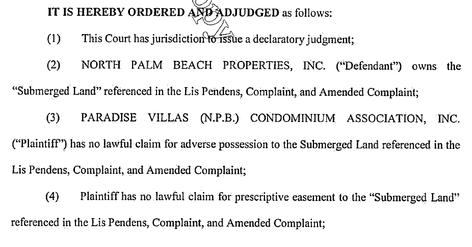
Some would say that’s the ball game. Get your check book out if you own a ‘waterfront’ parcel shown on what you thought was the “Earman River”. Some lawyers and property owners are still trying to dispute this and we’ll see if they are successful or not. It has been pointed out to me that this case has yet to be heard by a judge and and that the above excerpt is not a judgement entered by a judge but rather stipulations agreed to by the parties.

Other plats recorded such as Plat 6 for the houses around Lagoon and Waterway Drive specifically dedicates the area on the plat shown as ‘Lagoon, Lake or Waterway’ to the Village of North Palm Beach subject to this same document recorded in Official Record Book 6 Page 393. This would be the westerly half main waterway beginning on the north side of the Lighthouse Bridge. The POB on this plat looks to be wrong. It states that it starts at the intersection of the centerline of the NBP Waterway with the centerline of Lighthouse drive as show on the adjacent plat but NO SUCH point is shown on the plat. The legal description on this plat does clearly run down the centerline of the NPB Waterway. The issue is that the legal description for the Golf Course Addition No 1 and No 2 ONLY go to the bulkhead line on the east side of the waterway and are silent on any use of the adjacent waterway by the uplands abutters.

Plat_Book_26_Page_10_Plat_6Download

The Country Club Addition Plat for the houses on Pilot, Riverside and Shore Roads also uses the same language of Plat 6 dedicating the land below the Lagoons and Waterways to the Village subject to this same document recorded in Official Record Book 6 Page 393. This plat extends to the west side of the North Palm Beach Waterway.

Plat_Book_25_Page_130_County_Club_AdditionDownload

The Golf Course Addition for the houses along Country Club Drive north of Shore Rd does not say ANYTHING about the waterway. It shows the “North Palm Beach Waterway” on the plat but the legal description does not cover anything past the bulkheads. And it is silent on the use of the adjacent waterway by the uplands abutters.

Plat_Book_27_Page_96_Golf_Course_AddDownload

The Country Club Addition Number 2 for the houses at the very end of Country Club Drive and also does not say ANYTHING about the waterway. It does show the “North Palm Beach Waterway” on the plat but again the legal description does not cover anything past the the approximate sea wall. And it too is silent on the use of the adjacent waterway by the uplands abutters.

Plat_Book_28_Page_67_Golf_Course_Addition_No_2Download

I thought the above is a problem for years for a few reasons. The first being that the legal description of Plat 6 on the west side of the main waterway only goes to the centerline of the North Palm Beach Waterway and only up to just inside of the current Harbour Isles basically. The plats on the east side of the main waterway (Golf Course Addition 1 & 2) only goes to the sea wall line. In short, there’s a gap being the east 1/2 of the “North Palm Beach Waterway” from Half Moon Lagoon to the north end of Plat 6 and perhaps the full width of the canal from the end of Plat 6 to the intracoastal.

And then I recently discovered the mssing link in this “hole”. The NPB Waterway in this are was not dedicated on the face of a plat as others were. It was dedicated via a recorded document ORB 644 Page 269…

ORB_222_PG_348_and_ORB_644_PG_269Download

And how about the canals east of US-1 over by Frigates like the C-17, the canals with the condos around them south of it and houses behind the police station along Bowsprit, Davit & Ebbtide? This is super interesting. This land was in the first bulk sale from MacArthur to North Palm Beach Inc. who a few years later sold it back to MacArthur. MacArthur then records

Plat_Book_25_Page_167_Palm_Beach_Lake_Worth_EstatesDownload

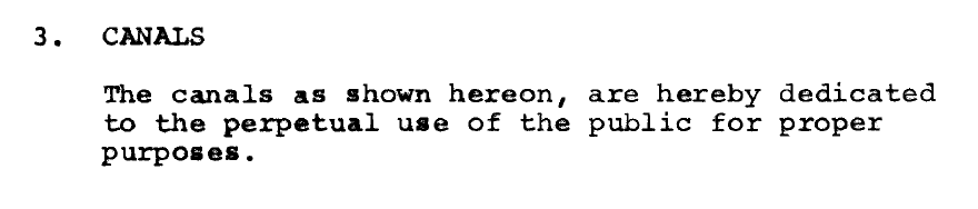
Which shows the C-17 labeled as a canal as the others are and dedicates them on the face of the plat “to the perpetual use of the public, as public highways and waterways, the streets and canals as shown hereon”…

Now when a street is dedicated ot he public, that’s everyone. Again, seems straight forward to me that Frigates, the condos, Nautical Ventures and the rest of the folks on the C-17 east of US-1 should not have paid a nickel to use the C-17.

The houses on Davit and Ebbtide were actually part of re-plat. MacArthur solf that area to American Realty who reverted the plat and then re-plat’d it and they dedicated the canals to the perpetual use of the public for “proper” purposes.

Plat_Book_35_Page_143_Palm_Beach_LW_EstatesDownload

So yet a different verbiage again. What a hot mess and nothing that would seem to allow the uplands abutter any more right to build a dock than any other member of the public. This plat only goes to the half way point (+/-) of the canal that separates this community from the Yacht Club Addition, where I live, and that plat (Yacht Club Addition) uses the same language as the others plats referencing the document in Official Record Book 6 Page 393. So, Half of the canal is for “proper public use” and the other half is subject to the usual NPB use restrictions.

Plat_Book_25_Page_249_Yacht_Club_Addition-1Download

Part of this area is the intracoastal waterway.

If you’re still reading this then you can see that ownership of waterfront property can be VERY tricky. If you want buy or sell your property with someone who knows all about these things then call me, Chris Ryder at 561.626.8550.

Filed Under: Blog, Frequently Asked Questions

10 Questions to ask when buying a waterfront house in Florida.

October 5, 2019 by Chris Ryder

What 10 Questions to ask when buying a waterfront house in Florida.

  1. Who owns the land below the water? Was the water “navigable” when Florida entered the Union? Does the lot enjoy “riparian” rights? There are 2 basic types of land below water in Florida, land owned by the state and subject to “navigational servitude” and over flowed land owned by sometimes the state but most of the time someone else. Here’s an example for a property on the St. Lucie River.
  2. If the land below the water is NOT owned by the State of Florida then who does own it? What rights have they conferred upon uplands abutters and what, if any, restrictions have they placed upon them and the use of the water column above the “over flowed” land they own?
  3. If the land below the water is not owned by the state is there an easement recorded in the public record, or some other right, for the benefit of the subject property to pass over the submerged lands of others until one reaches “navigable” waters where as part on the ‘navigational servitude’ the general public enjoys “rights of navigation”? It’s nott just where your dock is. You need a path to the waterway out to where the general public enjoys “rights of navigation”.
  4. If the land below the water is not owned by the State of of Florida then who maintains the canal? The municipality? The HOA? Or, is there a canal maintenance agreement recorded that provides triggers and apportion of expenses to the uplands lot owners, pperhaps through an HAO.
  5. When was the sea wall constructed? Is it on the bulkhead line, if applicable, or on or past the lot line?
  6. How wide is the canal from sea wall to lot line to lot line, sea wall to sea wall or dock to dock?
  7. How far into the canal can one go with a dock? Or with a boat? Or with dolphin or tie off piles?
  8. Can I aplce a lift in the dock and are there any limits as to how many, or what kind of, boats I may keep there?
  9. What is the flood zone designation of the house on the lot and is there a benchmark for an elevation someplace?
  10. When was the dock constructed? And, is EVERYTHING about the dock, and sea wall, properly permitted?

The above are technical and require some thought. If you’re looking for a Broker who has “done their homework”. Some other basic questions to ask afte r those above are:

  1. Are there any shallow spots between this property and the open water?
  2. Are there slow speed zones between the property and open water?
  3. Is there a path to the open water that does not require one go under a fixed bridge
  4. What are the closed bridge heights between the property and open water? Jupter area bridge clearances.
  5. Is the property on city sewer or on-site septic. There’s a push right now, for good reason, to get waterfront parcels onto city sewer and if this happens it will cost you $$$.
  1. When was the sea wall constructed? Obvious but the sea wall has a life span just like a roof. If it needs to be replaced does it need to be a particular material, like concrete? Can it be moved further out into the waterway?
  2. How wide is the canal? Again, an obvious question but ask it to know if the uplands contiguous with the property you’re interested in are part of the property or inside of the supposed canal.
  3. How far into the canal can one go with a dock? Or with a boat? A typical answer is 1/3 but it may be 1/4 or even less.
  4. What is the flood zone designation of the house on the lot and is there a benchmark for the elevation someplace? If your buying something on the water then the flood zone is a MAJOR factor. Most places have a base flood elevation or BFE that is set on the FEMA maps. This affects the ability to finance and potentially rebuild in the event of a flood loss and MUCH MUCH more.
  5. Who owns the land below the water? Is it riparian or littoral rights water? It it’s riparian then you have the right to get out to ‘navigable’ water with your dock but the state of Florida owns the land below the water. If it’s littoral then someone (you, an association or even a municipality) owns the land under the water.
  6. Who maintains the land below the water? If you think building a new sea wall is expensive then try dredging out that walerway and disposing of all the spoils. Who’s paying for that?
  7. Are there any shallow spots between this property and the open water? If you’re really interested in a property then BEFORE you own it make a ‘dry run’ from the dock to wherever and do so at low tide. You’d hate to buy a place and then find out there’s a ‘hump’ at the end of the canal that you can’t get past.
  8. Is there a path to the open water that does not require one go under a fixed bridge? You may not own a sailboat but think like you do, they buy property too.
  9. What are the closed bridge heights between the property and open water? In a hurricane the bridges get ‘locked down’ or remain in the closed position. Also, life is allot easier if one does not have to sit around waiting on bridges to open.
  10. Is there a limit on the number of boats I can store here or the type of boat I can have here? Some municipalities and associations limit these. They also can be limited by the DEP permit which may say something like only 1 motorized vessel per lot and a jet ski counts.

There are allot more questions that I would ask but starting with these will lead into conversations that should answer 90% of the concerns.

Filed Under: Blog, Frequently Asked Questions

How to calculate Citizens mitigation discounts?

August 16, 2019 by Chris Ryder

I decided to revisit this subject. I recently received my insurance bill from citizens and I started to go down over it to check all the categories and make sure I was properly rated. I am, but I searched the internet for a revised wind mitigation discount table to the one I obtained years ago and it is still a VERY closely guarded item and NO PLACE on the internet that I could find except RIGHT HERE.

HW wind mitigationDownload

Here’s the question I get all the time. Does it pay to install new hurricane shutters or impact rated windows. First, the market WILL pay a premium for a home with impact windows but this is about 60% of what you will spend to install them. The building code, and your insurance see impact windows and storm shutters as the same required impact resistance. So how much will I save on my insurance each year if I have a COMPLETE set of shutters and/or impact rated windows?

There’s some basic math involved here so get ready for it. First let’s show how the table from above is used. My annual premium this year, BEFORE all the sure charges like the catastrophe Fund Build-up, is $1,823. The next page notes a premium adjustment of 7,292 was applied to obtain this number. Thus, 7292+1823 = 9115, and this is the UNADJUSTED premium. We can see that for me my premium is 1823/9115 or 20% of the unadjusted premium. Now look at the table. At my house I have an FBC equivalent roof, type B roof deck attachment, single wrap wall to truss connectors, no SWR (secondary water resistance), and an “other” roof shape (Don’t even get me started) and all with Class A hurricane protection shutters. Looking at the table NOTED ABOVE we see the adjustment is 0.2, or 20%. Isn’t math grand.

OK, so what if I do not have hurricane shutters or my credit was removed because the system was not 100% coverage? If this credit was removed, as mine was during the depopulation period, then the mitigation discount goes from 0.2 to 0.42, a difference of 22%. For my house that would be 22% of 7,292 or $1,604. So if my home required all new shutters and one installed the Class A (High Velocity Hurricane Zone a/k/a Miami Dade) shutters as I did then each year I get $1,604 in premium savings. I spent a little under 2k on the materials and several weekends installing these but that was now 6 years ago. So I have saved $9,625 during that time by spending 2k.

The above math is very clear. Shutters are soooo worth it. But I also did things like added nails to my straps so that I got the discount for single wraps as opposed the clips. This saved me (0.22-0.2)*(7292) = ~146/year or ~875 over the last 6 years. Was this worth a day of my life crawling around my attic with a palm nailer adding nails to the straps? For me, I would say yes as it’s $146 I save every single year in savings or $875 in the last 6 years for about $150 and half a day of my life.

Filed Under: Blog, Frequently Asked Questions

Does the Seller have to make repairs?

August 14, 2019 by Chris Ryder

Despite the name of the contract used in 95% of all sales in Florida being the “As-Is Contract” many buyers still expect the Seller to make repairs.

Does the Seller have to make repairs to the property found by the the Buyer during the inspection period?

Short Answer: NO! Unless it is NOT an AS-IS Contract.

Long Answer: 95% of the time we use as As-IS Contract. The Buyer is agreeing to buy the property (or not) in its’ AS-IS condition. Just because the Buyer found problems with the property during the inspection period does NOT obligate the Seller to make repairs or give credits or do anything other than maintain the property in the condition it was in on the Effective Date of the Contract.

Most of the time though the Buyer and Seller work something out. The reality is that they are both invested by the time this conversation comes up. In my experience, the Seller would be wise to be reasonable. Properties which come back on the market after a sale falls through typically sell for less. Remember that BOTH the Seller AND the Realtor are required to disclose all known defects which may materially affect the value of the property and are not readily observable to a Buyer. Thus, the agent must disclose any knowledge they have of any defects to the next potential Buyer.

Bottom line. Sellers, be reasonable. The Buyer only found the defects in your Property. They did not cause them. Buyers, be reasonable. All properties have defects and everything is worth owning at the right number.

Filed Under: Blog, Frequently Asked Questions

How Big & How Many docks can one have?

June 18, 2019 by Chris Ryder

The first question is does one want to do a quick and easy permit? These are the permits for docks/piers which comply with the automatic exemptions allowed for in the Florida statute and the FL Administrative Code. YES! Good choice. PRINT THIS OUT AS THIS IS A LOOOONG POST. Looking for a Realtor who knows about these things? Give me (Chris Ryder) a call at 561.818.3858.

This pdf document prepared by DEP will give you an overview

First, ask what is the nature of your waterfront property rights, does that waterfront land enjoy Riparian Rights? But, let’s cover the man made canal or “over flowed lands” first as this is what most folks will have. For docks on a man made canal, these are termed as being on an “artificially created waterway” in the applicable statute and FAC. BEFORE GOING TOO FAR! Check any restrictions noted on the recorded deed, plat and/or within the HOA documents and THEN check the local zoning ordinance. Remember that the land under that water is literally owned by someone. In an “artificially created waterway” it’s owned by someone other than the state. That land can and often does have use restrictions recorded in the public record.

FOR DOCKS CONSTRUCTED OVER AN ARTIFICIALLY CREATED WATERWAY…

FS 403.813(1)(i) The construction of private docks of 1,000 square feet or less of over-water surface area and seawalls in artificially created waterways where such construction will not violate existing water quality standards, impede navigation, or affect flood control. This exemption does not apply to the construction of vertical seawalls in estuaries or lagoons unless the proposed construction is within an existing man made canal where the shoreline is currently occupied in whole or part by vertical seawalls.

FAC 62.330.051(5)(c) Construction of private docks or piers of 1,000 square feet or less of over-water surface area in artificial waters in accordance with section 403.813(1)(i), F.S., and within residential canal systems legally in existence under chapter 403 or part IV of chapter 373, F.S. This includes associated structures such as roofs and boat lifts, provided the cumulative square footage of the dock or pier and all associated structures located over wetlands and other surface waters does not exceed 1,000 square feet

Note that in this case (artificially created waterway) the FS and FAC do NOT limit the number of vessels allowed to be docked, only the the total s.f. of what is termed ‘Shade Area’ and for most of you this will be 1000 s.f. of dock.

FOR DOCKS THAT ENJOY RIPARIAN RIGHTS…

The Department (FDEP) has the authority to review activities on sovereign submerged lands under Chapters 253 and 258 of the Florida Statutes, and Chapters 18-20 and 18-21 of the Florida Administrative Code, F.A.C.

For docks which are located on riparian waterways, where the land below the water is owned by the state of Florida, then basically one may have a dock configured for 2 vessels and the same 1000 s.f. of shade area, OR under the 10:1 ratio of 10 SF of dock for every 1 linear foor ot riparian water frontage, plus a few other dimensional limits like being less than 4 feet wide in an ‘easy’ permit. Docks for 3 or more vessels would be a “multi-slip facility” which technically are allowed for a residential parcel outside of the keys but have more stringent permitting requirements including a submerged lands lease, and requiring a “general permit”. And, of course must be OK with local zoning laws and any HOA rules.

Docks for riparian waterfront owners are governed by these laws and rules…

FS 403.813(1)(b) The installation and repair of mooring pilings and dolphins associated with private docking facilities or piers and the installation of private docks, piers and recreational docking facilities, or piers and recreational docking facilities of local governmental entities when the local governmental entity’s activities will not take place in any manatee habitat, any of which docks:

  1. Has 500 square feet or less of over-water surface area for a dock which is located in an area designated as Outstanding Florida Waters or 1,000 square feet or less of over-water surface area for a dock which is located in an area which is not designated as Outstanding Florida Waters;
  2. Is constructed on or held in place by pilings or is a floating dock which is constructed so as not to involve filling or dredging other than that necessary to install the pilings;
  3. Shall not substantially impede the flow of water or create a navigational hazard;
  4. Is used for recreational, noncommercial activities associated with the mooring or storage of boats and boat paraphernalia; and
  5. Is the sole dock constructed pursuant to this exemption as measured along the shoreline for a distance of 65 feet, unless the parcel of land or individual lot as platted is less than 65 feet in length along the shoreline, in which case there may be one exempt dock allowed per parcel or lot.

Nothing in this paragraph shall prohibit the department from taking appropriate enforcement action pursuant to this chapter to abate or prohibit any activity otherwise exempt from permitting pursuant to this paragraph if the department can demonstrate that the exempted activity has caused water pollution in violation of this chapter.

FAC 62.330.051(5)(b) Installation of private docks, piers, and recreational docking facilities, and installation of local governmental piers and recreational docking facilities, in accordance with section 403.813(1)(b), F.S. This includes associated structures such as boat shelters, boat lifts, and roofs, provided:

1. The cumulative square footage of the dock or pier and all associated structures located over wetlands and other surface waters does not exceed the limitations in section 403.813(1)(b), F.S.;

2. No structure is enclosed on more than three sides with walls and doors;

3. Structures are not used for residential habitation or commercial purposes, or storage of materials other than those associated with water dependent recreational use; and

4. Any dock and associated structure shall be the sole dock as measured along the shoreline for a minimum distance of 65 feet, unless the parcel of land or individual lot as platted is less than 65 feet in length along the shoreline, in which case there may be one exempt dock allowed per parcel or lot.

If this is not enough then one MAY apply for a “general permit” which must meet the requirements below but be aware of the now explicit limitations of same…

62-330.427 General Permit for Docks, Piers and Associated Structures.

(1) A general permit is granted to any person to construct, extend, or remove a dock or pier and associated structures as described below:

(a) A private, single-family pier or dock with up to two boat lifts that, together with all existing structures on the shoreline of the property, does not exceed a total area of 2,000 square feet over surface waters. Such a structure:

1. Shall not accommodate the mooring of more than two vessels, either in the water or on a boat lift. Solely for purposes of this general permit, up to two personal watercraft as defined in section 327.02(33), F.S., may be moored in lieu of either or both allowable vessels of another type. These limits shall not apply to the mooring, storage or other use of the dock or pier by:

a. Non-motor-powered vessels less than 16 feet in length that are stored on or under the dock or pier, or within an authorized mooring area; or

b. Personal watercraft, dinghies or similar small vessels that are stowed out of the water, upon a larger parent vessel that is moored at the dock in compliance with this general permit.

2. Shall be located such that all areas used for vessel mooring and navigational access already provide a minimum depth of two feet below the mean low water level for tidal waters, or two feet below the expected average low water depth for non-tidal waters as determined based on best available information for the water body at the project location; and

3. May include a roof over the vessel mooring areas, boat lifts, and terminal platform, or any portions thereof, subject to the applicable provisions of chapters 253 and 258, F.S., and the rules adopted thereunder. Portions of such roofs that overhang beyond the edge of decked portions of the pier or dock shall be included in the calculation of the total square footage of over-water structure allowed under paragraph (1)(a), above.

(b) A public fishing pier that does not exceed a total area of 2,000 square feet provided the structure is designed and built to discourage boat mooring by elevating the fishing pier to a minimum height of five feet above mean high water or ordinary high water, surrounding the pier with handrails, and installing and maintaining signs that state “No Boat Mooring Allowed.”

(2) This general permit shall be subject to the following specific conditions:

(a) Construction or extension of the boat lift, boat mooring locations, or terminal platform, shall not occur over submerged grassbeds, coral communities or wetlands. However, the access walkway portion of the pier may traverse these resources provided it is elevated a minimum of five feet above mean high water or ordinary high water, contains handrails that are maintained in such a manner as to prevent use of the access walkways for boat mooring or access, and does not exceed a width of six feet, or a width of four feet in Aquatic Preserves;

(b) There shall be no structures enclosed by walls, screens, or doors on any side;

(c) The dock or pier will not facilitate vessel rentals, charters, or serve any other commercial purpose;

(d) There shall be no fish cleaning facilities, boat repair facilities or equipment, or fueling facilities on the structures authorized by this general permit. In addition, no overboard discharges of trash, human or animal waste, or fuel shall occur from any structures authorized by this general permit;

(e) This general permit shall not authorize the construction or extension of more than one dock or pier per parcel of land or individual lot. For the purposes of this general permit, multi-family living complexes shall be treated as one parcel of property regardless of the legal division of ownership or control of the associated property; and

(f) Notwithstanding any other provisions of this general permit, the design, construction and operation of the dock or pier and associated vessels shall not conflict with any manatee protection plan approved and adopted under section 379.2431(2)(t), F.S.

62-330.475 General Permit for Single-family Residential Activities in Isolated Wetlands.

(1) A general permit is granted to construct, alter, maintain, operate, abandon, and remove a single family residence and associated residential improvements (such as a driveway, garage, and an onsite sewage disposal system), provided:

(a) The land on which the work is to occur is not part of a larger plan of common development;

(b) The notice required in rule 62-330.402, F.A.C., includes documentation that the tract of land was not divided into two or more parcels after July 1, 1994;

(c) Work occurs only in uplands or in isolated wetlands that are not within an Area of Critical State Concern or within the Wekiva River Basin Riparian Habitat Protection Zone as described in subparagraph 40C-41.063(3)(e)1., F.A.C.;

(d) Wetland impacts shall be eliminated except where unrestricted uplands are insufficient to support the residence and associated residential improvements. “Unrestricted uplands” are uplands that are not restricted by easement, deed restriction, local government regulation, setback, or similar restriction which would prevent construction there. Uplands are not considered restricted until all available variance or waiver procedures have been exhausted;

(e) Wherever possible, structures in isolated wetlands should be built on pilings to minimize fill in wetlands; and

(f) No more than 4,000 square feet of isolated wetlands are dredged or filled and no more than 6,000 square feet of isolated wetlands are cleared (this includes the area dredged or filled for the residence and associated residential improvements).

(2) Persons proposing to use this general permit must provide, as part of the notice required in rule 62-330.402, F.A.C., reasonable assurance that the proposed activity:

(a) Does not cause a violation of state water quality standards;

(b) Does not impede the conveyance of a stream, river, or other watercourse in a manner that would increase off-site flooding;

(c) Does not adversely impact aquatic or wetland dependent listed species;

(d) Does not cause the drainage of wetlands.

(3) The Agency will provide written notification to the person proposing to use this general permit whether the proposed activity qualifies for this general permit within 30 days of submittal of the written notice. The proposed activity shall not be commenced until the Agency has provided written notice that the applicant qualifies for the general permit.

(4) This general permit shall not be applicable on any parcel of property which has been the subject of the successive filing of notices under a general permit within a three-year period where the combination of activities to be conducted exceed the thresholds in this rule.

If you happen to still be reading then you know that the devil is not in the details but rather the definitions…

“Dock” means a fixed or floating structure, including access walkways, terminal platforms, catwalks, mooring pilings, lifts, davits and other associated water-dependent structures, used for mooring and accessing vessels.

“Pier” means a fixed or floating structure used primarily for fishing or swimming and not designed or used for mooring or accessing vessels.

“Minimum-size dock or pier” means a dock or pier that is the smallest size necessary to provide reasonable access to the water for navigating, fishing, or swimming based on consideration of the immediate area’s physical and natural characteristics, customary recreational and navigational practices, and docks and piers previously authorized under this chapter. The term minimum-size dock or pier shall also include a dock or pier constructed in conformance with the exemption criteria in section 403.813(1)(b), F.S., or in conformance with the private residential single-family dock criteria in subsection 18-20.004(5), F.A.C.

FAC 18-20.004(5) STANDARDS AND CRITERIA FOR DOCKING FACILITIES.

(a) All docking facilities, whether for private residential single-family docks, private residential multi-slip docks, or commercial, industrial, or other revenue generating/income related docks or public docks or piers, shall be subject to all of the following standards and criteria.

1. No dock shall extend waterward of the mean or ordinary high water line more than 500 feet or 20 percent of the width of the waterbody at that particular location, whichever is less.

(An interesting note here is that the FAC 18.20.004(5) states that no dock shall extend more than 20% of the width of the water body. BUT 25%?)

2. Certain docks fall within areas of significant biological, scientific, historic or aesthetic value and require special management considerations. The Board shall require design modifications based on site specific conditions to minimize adverse impacts to these resources, such as relocating docks to avoid vegetation or altering configurations to minimize shading.

3. Docking facilities shall be designed to ensure that vessel use will not cause harm to site specific resources. The design shall consider the number, lengths, drafts and types of vessels allowed to use the facility.

4. In a Resource Protection Area 1 or 2, any wood planking used to construct the walkway surface of a facility shall be no more than eight inches wide and spaced no less than one-half inch apart after shrinkage. Walkway surfaces constructed of material other than wood shall be designed to provide light penetration which meets or exceeds the light penetration provided by wood construction.

5. In a Resource Protection Area 1 or 2, the main access dock shall be elevated a minimum of five (5) feet above mean or ordinary high water.

6. Existing docking facilities constructed in conformance with previously applicable rules of the Board and in conformance with applicable rules of the Department are authorized to be maintained for continued use subject to the current requirements of chapter 18-21, F.A.C. Should more than 50 percent of a nonconforming structure fall into a state of disrepair or be destroyed as a result of any natural or manmade force, the entire structure shall be brought into full compliance with the current rules of the Board. This shall not be construed to prevent routine repair.

(b) Private residential single-family docks shall conform to all of the following specific design standards and criteria.

1. Any main access dock shall be limited to a maximum width of four (4) feet.

2. The dock decking design and construction will ensure maximum light penetration, with full consideration of safety and practicality.

3. The dock will extend out from the shoreline no further than to a maximum depth of minus four (-4) feet (mean low water).

4. When the water depth is minus four (-4) feet (mean low water) at an existing bulkhead the maximum dock length from the bulkhead shall be 25 feet, subject to modifications accommodating shoreline vegetation overhang.

5. Wave break devices, when requested by the applicant, shall be designed to allow for maximum water circulation and shall be built in such a manner as to be part of the dock structure.

6. Terminal platform size shall be no more than 160 square feet.

7. If a terminal platform terminates in a Resource Protection Area 1 or 2, the platform shall be elevated to a minimum height of five (5) feet above mean or ordinary high water. Up to 25 percent of the surface area of the terminal platform shall be authorized at a lower elevation to facilitate access between the terminal platform and the waters of the preserve or a vessel.

8. Docking facilities in a Resource Protection Area 1 or 2 shall only be authorized in locations having adequate existing water depths in the boat mooring, turning basin, access channels, and other such areas which will accommodate the proposed boat use in order to ensure that a minimum of one foot clearance is provided between the deepest draft of a vessel and the top of any submerged resources at mean or ordinary low water; and,

9. Dredging to obtain navigable water depths in conjunction with private residential, single-family dock applications is strongly discouraged.

(c) Private residential multi-slip docks shall conform to all of the following specific design standards and criteria.

“Multi-slip docking facility” means any marina or dock designed to moor three or more vessels.

1. The area of sovereignty, submerged land preempted by the docking facility shall not exceed the square footage amounting to ten times the riparian waterfront footage of the affected waterbody of the applicant, or the square footage attendant to providing a single dock in accordance with the criteria for private residential single-family docks, whichever is greater. A conservation easement or other similar legally recorded use restriction must be placed on the riparian shoreline, used for the calculation of the 10:1 threshold, to conserve and protect shoreline resources and subordinate or waive any further riparian rights of ingress and egress for additional docking facilities.

2. Docking facilities and access channels shall be prohibited in a Resource Protection Area 1 or 2, except as allowed pursuant to section 258.42(3), F.S., while dredging in Resource Protection Area 3 shall be strongly discouraged.

3. Docking facilities shall not terminate in a Resource Protection Area 1 or 2; however, main access docks will be allowed to pass through a Resource Protection Area 1 or 2, to reach a Resource Protection Area 3, when reasonable assurances are provided that such crossing will generate no significant negative environmental impact.

4. Main access docks and connecting or cross walks shall not exceed six (6) feet in width.

5. Terminal platforms shall not exceed eight (8) feet in width.

6. Finger piers shall not exceed three (3) feet in width, and 25 feet in length.

7. If requested by the applicant, pilings may be used to provide adequate mooring capabilities.

8. The provisions of paragraph 18-20.004(5)(d), F.A.C., shall also apply to private residential multi-slip docks.

(d) Commercial, industrial and other revenue generating/income related docking facilities shall conform to all of the following specific design standards and criteria.

1. Docking facilities shall be authorized only in locations having adequate circulation and existing water depths in the boat mooring, turning basin, access channels, and other such areas which will accommodate the proposed boat use to ensure that a minimum of one foot clearance is provided between the deepest draft of a vessel and the bottom of the waterbody at mean or ordinary low water.

2. Docking facilities and access channels shall be prohibited in a Resource Protection Area 1 or 2, except as allowed pursuant to section 258.42(3), F.S.; while dredging in Resource Protection Area 3 shall be strongly discouraged.

3. Docking facilities shall not terminate in Resource Protection Area 1 or 2; however, main access docks will be allowed to pass through Resource Protection Area 1 or 2, to reach a Resource Protection Area 3, when reasonable assurances are provided that such crossing will generate no significant negative environmental impact.

4. Docking facilities shall be sited to ensure that boat access routes avoid injury to marine grassbeds or other aquatic resources in the surrounding areas.

5. Expansion of existing facilities shall take precedence over approval of new facilities.

6. Use of upland dry storage shall take precedence over the creation of new wet slips.

7. Marinas shall not be sited within state designated manatee sanctuaries.

8. In any areas with known manatee concentrations, manatee awareness signs or informational displays shall be specified as part of a wetland resource or environmental resource permit for the facility.

(e) Alterations to the criteria in subsection 18-20.004(5), F.A.C., shall be authorized to accommodate persons with disabilities or to comply with Americans with Disabilities Act.

Filed Under: Blog, Frequently Asked Questions

What if the condo docs are incomplete?

June 3, 2019 by Chris Ryder

Source: What if the condo docs are incomplete?

It’s common knowledge in the real estate industry that a Buyer in Florida is entitled to a collection of documents before purchasing a condominium. This rule, as it applies to non-developers, can be found at Chapter 718.503(2), Florida Statutes. The language you see in all capital letters below is taken directly from this section of the statute and is found in the required Condominium Addendum to the Contract between the parties.

Section 5 of the Florida Realtors/Florida Bar Condominium Rider, titled Non-Developer Disclosure, gives the parties two options. The first option is to use a clause that begins “THE BUYER HEREBY ACKNOWLEDGES THAT BUYER HAS BEEN PROVIDED A CURRENT COPY OF THE DECLARATION OF CONDOMINIUM”

The parties should select this option ONLY if the buyer received all listed documents at least three business days before signing the contract, since it means that the document delivery issue is put to rest as soon as buyer signs the contract. Courts will be very reluctant to give any relief to a buyer who agrees to this clause without first confirming it’s completely accurate unless there are unusual additional facts. Although this clause is always an option for the parties, they don’t tend to use it very often.

Parties typically choose the second clause, which begins “THIS AGREEMENT IS VOIDABLE BY BUYER BY DELIVERING WRITTEN NOTICE OF THE BUYER’S INTENTION TO CANCEL WITHIN 3 DAYS, EXCLUDING SATURDAYS, SUNDAYS, AND LEGAL HOLIDAYS, AFTER THE DATE OF EXECUTION OF THIS AGREEMENT BY THE BUYER AND RECEIPT BY THE BUYER OF A CURRENT COPY OF THE DECLARATION”

When this clause is in place, the buyer has a right to void the contract until three business days after receipt of ALL listed condominium documents. In most cases, the seller will deliver all documents, and the three business days will pass without incident.

But what happens if a seller refuses or neglects to deliver ALL of the documents? What if a condominium association refuses to provide all required documents? What if a bank-owned property seller doesn’t even attempt to deliver documents?

The answer to all of these questions is in the last sentence of the clause, which simply states BUYER’S RIGHT TO VOID THIS AGREEMENT SHALL TERMINATE AT CLOSING.”

What this means: If the Buyer doesn’t receive some or all the condominium documents, the Buyer will have to decide whether that’s enough of a reason to walk away from the transaction before Closing.

Of course, the buyer is welcome to try and find the documents on their own by asking a community association manager, officer of the association or anyone else who may be able to help them out.

If the buyer isn’t successful, though, they have a decision to make: Are they comfortable enough closing with incomplete condominium documents? If not, then their option is to void the contract right up to the Closing.

Filed Under: Blog, Frequently Asked Questions

  • « Previous Page
  • 1
  • …
  • 18
  • 19
  • 20
  • 21
  • 22
  • …
  • 40
  • Next Page »

Benjamin Saunders
a year ago

I highly recommend R&R Realty! From the professional pictures and listing to the consistent updates and strategy, my experience could not have been better. If you're looking to sell or buy a property in South Florida, R&R Realty is your best bet.

Cathy Ingraham
a year ago

Nicole Ryder is amazing. Her expertise and knowledge in real estate shines through in many ways. Nicole knows the market, is extremely responsive, knows exactly what listings to present, and an exceptional communicator! Nicole has done an outstanding job at answering all my questions (and I’ve had a lot), keeping us informed of market changes and proactive in bringing us new ideas and listings. Highly recommend, Nicole Ryder. Can’t ask for a better experience. 10/10 ⭐️⭐️⭐️⭐️⭐️⭐️⭐️⭐️⭐️⭐️

Crystal Lewis
4 years ago

I highly recommend R & R Realty. Chris worked with me to over a period of years to find what I wanted. He always responded quickly to my phone calls or texts. Chris always pointed out all the positives of a property but also possible negatives or things I hadn't thought of. It was a pleasure working with him.

Amanda Davis
7 years ago

Chris and Nicole Ryder are true professionals! They both helped my husband and I find our apartment when we were new to South Florida and were an excellent source of information about the Palm Beach Gardens/Juno Beach/Jupiter area. When we decided to buy a property two years later, we came back to R&R Realty without hesitation. Chris patiently worked with us for many months as we slowly but surely developed a sense of what we wanted. He went above and beyond, giving us not only real estate advice but also engineering tips and personal recommendations. We ultimately found a house we love thanks to Chris's diligence and tireless efforts on our behalf. I can't recommend R&R Realty highly enough!

tara connelly
8 years ago

Chris Ryder was a fantastic realtor! Thorough start to finish! Helped us buy our first property here 8 years ago sold it for us and helped us buy a second. Will most definitely be calling him again in the future.

John Bailey
8 years ago

Nicole Ryder (and Chris) provided excellent service throughout entire process of listing and selling condo in Juno Beach. Nicole was very helpful and always acted in our best interest re listing details, setting viewing appointments, responding to offers and assisting with closing requirements. We most appreciated their local knowledge and support re Florida real estate transaction requirements being non Florida residents. (Canada) We would highly recommend R&R Realty!

Matthew Pac
8 years ago

Chris is the very best realtor I have ever worked with anywhere in the country, by a long shot! Being from out of state, he spent countless hours previewing property, had a clear understanding what I was looking for, has the knowledge of an engineer/architect in evaluating structures plus is very familiar with the area. He is very patient, and never "sells" A true rare professional.

Hugh Jackson
9 years ago

I have used R&R Realty, The house Cris found for us is amazing. Cris definitely knows his business. No fooling around and gets the job done. I would definitely use Cris for further purchase. Thanks,Hugh

EI S
9 years ago

We have bought two properties through Chris and Nicole Ryder at R&R Realty. They have been a pleasure to work with--very honest, straightforward and down to earth. They truly listened to what we wanted and never pressured us to make a decision. They had great insights into local communities and readily shared their in depth knowledge of investment potential and building and construction issues. We felt totally comfortable recommending Chris and Nicole to friends who were equally pleased with their buying experience.

steve bromley
9 years ago

For most people, buying or selling a house is one of the most complicated financial transactions of a lifetime. Recently, we did BOTH, in a matter of months. Fortunately, we had Chris Ryder and his firm R&R Realty to work with, making the process as smooth as possible. At the beginning, we were absolute rookies, knowing nothing about the process, with a hundred questions, every day. Chris ALWAYS had time for us, communicating via phone, text, or email with me (Steve) and phone with Victoria, whatever we were most comfortable with. His knowledge of the Palm Beach County market (we sold our condo there) and beyond (we bought a condo in Martin County) is comprehensive. And his resources, from photographer, inspector, escrow, and mortgage broker are just as professional and thorough as he is. The staging of our condo for the listing photographs was wonderful! Chris is also a licensed contractor and an engineer, giving him expertise that other agents do not have. He was always ready to travel with us to see possible rentals in Palm Beach County, before we decided to buy, and then he was equally agreeable to turn the page and show us condos for purchase in Martin County. He involved us in every decision, giving advice when asked, but never making a choice for us. Every step was explained and we were always told the truth. When Victoria and I needed reassurance, he anticipated our needs. There were no surprises from start to finish, selling and buying. His integrity and work ethic - and his expertise and love of what he does - make him and R&R Realty the professionals we will always recommend!

Home Reviews

108 Lakeshore Drive, 1441, North Palm Beach

Enjoy sunrise to sunset views and ocean to intracoastal views from your spacious wrap around balcony at 108 Lakeshore Drive, 1441 in the Marina Tower building of Old Port Cove in North Palm Beach, Florida. This spacious 2 bedroom, 2 bathroom corner building condominium boasts floor to ceiling water views from every room. The unit […]

1801 N Flagler Drive 901, West Palm Beach, FL 33407

Experience true penthouse living in one of West Palm Beach’s most coveted waterfront communities. This exceptional residence at Flagler Pointe is one of only two penthouse level units with a direct, sweeping Intracoastal view—a vantage point so rare and breathtaking it simply cannot be replicated. From your living room, extended balcony, or primary bedroom, watch […]

400 Seaside Lane, Juno Beach, FL 33408

400 Seaside Lane, Juno Beach, FL 33408 https://www.flexmls.com/share/Dlg0h/400-Seaside-Lane,-Juno-Beach,-FL-33408 Rare Juno Beach Opportunity – Iconic Seaside Location This is your chance to own a truly special home in the charming Key West-style enclave of Seaside, one of the most coveted streets in Juno Beach. Just steps from the Atlantic Ocean and directly across from the beloved Pelican Lake […]

More Home Reviews

Frequently Asked Questions

FinCEN changes to Far Bar As-Is Contracts in Florida

There are new FinCEN reporting requirements for certain case sales in Florida and the thus the Far Bar As-Is was just updated with this: “FinCEN REAL ESTATE REPORTING OBLIGATION. Section 1031.320 of Chapter 31 of the Code of Federal Regulations (“CFR”) requires that certain residential real estate transactions without institutional lender financing, where at least […]

When is the Juno Beach Turtlefest in 2026

When will Turtlefest be held in Juno Beach in 2026? This year Turtlefest in Juno Beach, which is the annual even of Loggerhead Marinelife Center · 14200 US Highway 1 · Juno Beach, FL 33408 · USA will be held on February 21 & 22. Stop by R&R Realty in the Plaza Le Mer next […]

December and year end 2025 Jupiter and Palm Beach Gardens Housing sales numbers

Happy New Year! The Realtors Association of the Palm Beaches just released their December 2025 housing sales numbers and these are also the defacto year end numbers as well. I see the trend as going int he right direction. The key metric looking ahead is the months suuply of inventory which for houses has decreased […]

More Posts from this Category

From Our Blog

108 Lakeshore Drive, 1441, North Palm Beach

108 Lakeshore Drive, 1441, North Palm Beach

April 22, 2026 By Nicole Ryder

Enjoy sunrise to sunset views and ocean to intracoastal views from your spacious wrap around balcony at 108 Lakeshore Drive, 1441 in the Marina Tower building of Old Port Cove in North Palm Beach, Florida. This spacious 2 bedroom, 2 bathroom corner building condominium boasts floor to ceiling water views from every room. The unit has full hurricane impact slidders throughout along with accordian hurricane […]

400 Seaside Lane, Juno Beach, FL 33408

400 Seaside Lane, Juno Beach, FL 33408

April 10, 2026 By Chris Ryder

400 Seaside Lane, Juno Beach, FL 33408 https://www.flexmls.com/share/Dlg0h/400-Seaside-Lane,-Juno-Beach,-FL-33408 Rare Juno Beach Opportunity - Iconic Seaside Location This is your chance to own a truly special home in the charming Key West-style enclave of Seaside, one of the most coveted streets in Juno Beach. Just steps from the Atlantic Ocean and directly across from the beloved Pelican Lake walking trail, this property offers the perfect blend of Old […]

711 7th Lane, Palm Beach Gardens, FL 33418 

711 7th Lane, Palm Beach Gardens, FL 33418 

March 28, 2026 By Chris Ryder

https://www.flexmls.com/share/DhDWi/711-7th-Lane-Palm-Beach-Gardens-FL-33418 Discover this gorgeously remodeled Divosta built townhouse featuring 3 bedrooms, 2.5 baths, and tasteful upgrades. Known for quality construction, Divosta delivers peace of mind, while the extensive high end renovations throughout make this Garden Lakes home truly move-in ready. Step inside to an open concept kitchen equipped with smart technologies, brand new appliances, and custom finishes. The Kitchen flows seamlessly into the Living Room, […]

More Posts from this Category

About Us

For over twenty years now R& R Realty has been helping customers buy and sell Palm Beach homes. Northern Palm Beach County is a spectacular place to live and we know every inch of it. Generally considered the end of the sub tropical zone, the Gulf Steam waters temper our climate for warm winters making for an amazing life style filled with boats, beaches, shoping, golf & convenience just 15 minutes from the Palm Beach Airport. Feel free to browse our website for more information on Palm Beach homes for sale and real estate listings including great local neighborhood maps of Juno Beach, Jupiter, Palm Beach Gardens, Singer Island and Jupiter Island. You may choose to search for Palm Beach Homes for sale on your own at first or contact us and we will help tailor a search to your specific needs. We look forward to hearing from you! If you have any questions about property for sale in Palm Beach, please call me, Chris Ryder, the owner, directly on my cell phone at (561) 818-3858.

Return to top of page

Copyright 2025 R&R REALTY, INC. | Lic. Florida Real Estate Broker | Log out | Site Map | Privacy Policy | Copyright Notice

Click Here for Contact Information

R&R Realty

Jupiter Florida Real Estate

Phone: (561)626-8550
Fax: (561)626-8551

865 Donald Ross Rd
Juno Beach, FL 33408

Chris Ryder

Email: Realtor@RandRFlorida.com

URL: https://RandRFlorida.com

Hours:
Mo,Tu,We,Th,Fr: 9:00am-5:00pm
Sa: 9:00am-3:00pm

randrflorida