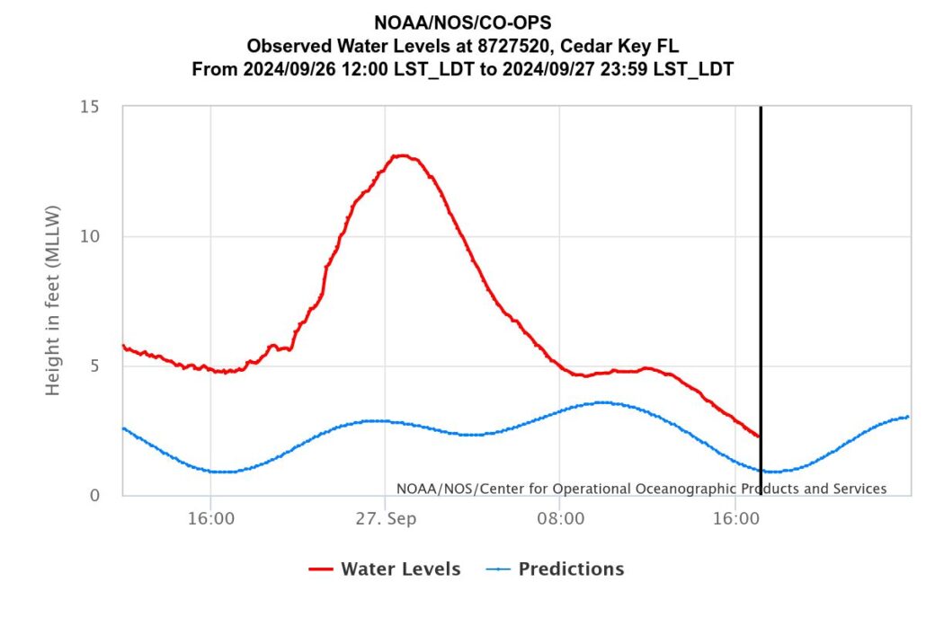
I have done a bunch of posts on flooding and storm surge here in Florida and mostly around Jupiter. Things like how to equate storm surge to the elevation of my house. As I did for Ian I looked at the NOAA tide guage and there is one in Ceday Key and it stayed “on line” for the whole storm. The picture says it all…

The storm surge is Cedar Key was the highest at about 1 AM on 27 September and was at ABOUT 13.1′ above the Mean Low Low Water (MLLW) for this location. The calculated tide for this day and location should have been ABOUT 2.75′ BUT the actual tides have been running about 1′ above what they were calulated to be. Still, “storm surge” is defined by NOAA as “Storm surge is an abnormal water level rise generated by a storm over and above the predicted astronomical tide.” The storm surge in Ceday Key for Hurricane Helene was thus ABOUT 13.1′-2.75′ = 10.35′.
If your interested, the MLLW at this location is -2.26′ by the NAVD 88 datum that we use to note things like the finished floor elevation of a house. If the finished floor of your house was ABOUT 8′ (10.35′-2.26′) by the NAVD 88 datum then just in terms of storm surge you should have been just above the water. Note that for Idalia, this number was about +8″ NAVD. But of course then there’s all that rain and then the local wind driven wave action that adds to this. The “localized” flooding.


