
Dates and Community Rating System Discounts for Palm Beach County
R&R Realty - Jupiter Real Estate
Find Jupiter-Palm Beach Gardens-Juno Beach-Singer Island-Jupiter Island property.
1219 N Lakeside Drive – This charming cottage in the Parrot Cove neighborhood of Lake Worth is CBS construction and was designed by Edgar S Norman. The home has views of the Lake Worth Golf Course and the intracoastal beyond and boasts a brand new 2021 roof and full impact doors and windows and a natural gas 20KW generator. Enter the home into a lovely window-lined sunroom with brick flooring and wood-beamed ceiling. The living room and dining area have a working fireplace and Miami Dade hardwood floors. The renovated kitchen has wood cabinets, granite countertops and an office nook. The home has a large backyard with a spacious deck with plenty of room for both a sitting and dining area. The single car detached garage has a full bathroom and can easily be used as a home office, gym, or art studio. The Parrot Cove neighborhood has no HOA fees. Enjoy living in a neighborhood where you can easily enjoy neighboring Lake Worth Golf Course, shops, restaurants and the multiple annual art, antique and food festivals.

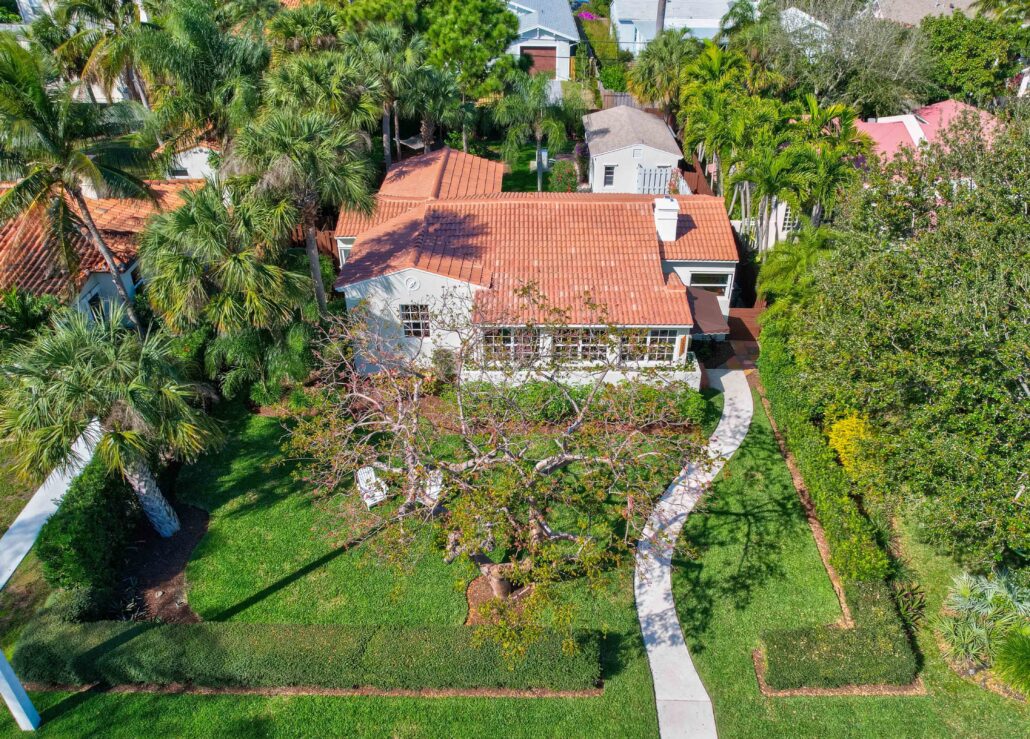
I read a VERY INTERESTING article today and I leaned something new. I have written about about the meander line and how that is shown on plats in Jupiter area. I also write about the troubles around this shown when perhaps not applicable along the C-17 a/k/a Earman River in North Palm Beach.
What I learned is that there are 2 types of land “owned’ by the state. The first is land which they acquired as a result of being granted statehood. This is what is called sovereign lands and was to be held in public trust. Sovereign, as in the Kings Land. Wait what? The original 13 colonies got, when we won the war for independance, the land below navigable waters as this was owned by the sovereign (the king) so subsequent states got this land too as the had to be on “equal footing” with the origioanl 13. Sovereign land is the lands below “navigable rivers, lakes, and tidelands are held in a public trust which imposes a legal duty upon the state to preserve and control them for public navigation, fishing, swimming, and other lawful uses.” The courts in Florida have upheld that even is one has a deed conveying these lands that the state had no right to sell it. WOW!
The second type of land the state acquired title to NOT as a result of simply becoming a state but lands which the Federal government GAVE to them by Act(s) of Congress with the INTENTION of being sold to, and utilized by, private citizens. I have written of how this land was used to create what would become the intracoastal waterway in the area. This is what is called “improvements lands”. These lands were sold to, or traded to, developers as payment for the creation of say a mile of canal, roadway or of a railroad.
In “1855 Florida Legislature created the Internal Improvement Fund, which consisted of title to internal improvement lands and swamp lands and all proceeds from the sale of such lands. The legislature then vested title to the internal improvement lands and swamp lands in the “Trustees of the Internal Improvement Fund” (the governor and cabinet) and gave them authority to sell and transfer the lands as prescribed by statute.”
OK, so perhaps you have read my blog posting on the what is called the Earman River and the issues with North Palm Beach Properties. In fact though, the “earman River” is NOT a river. It never was a river. It’s the C-17 canal managed by the South Florida Water Management District. Why do we call it the Earman River? I thought we had picked it up as a marketing name from the the developer of North Palm Beach. No one would pay more to live on the ‘C-17 Canal’ but the ‘Earman River’, that sounds VERY nice, someone just might pay me extra $$ to live on that. But as usual that’s about 1/2 the story.
Way back when the state of Florida was granted statehood, what we today call Lake Worth was an actual fresh water lake. On the west bank ONE WOULD ASSUME there was a small creek around where the C-17 is. Basic laws of human action are that we take the ath of least resistance whenever possible. Why do more work than we have to. So I would assume there was something there but perhaps not. I found this survey of the area done in 1859 and it clearly does NOT show any inlets or rivers. Thus it’s appears safe to say that the C-17 canal was not navigable in 1845 when florida entered the union as it was not “meandered” in 1859. Earman was the guy who farmed that area in the early 1900’s. Story is that he and a few other guys dug out this ( I assume) already low lying creek to drain the adjacent land for farming. It was “officially named for Earman after his death in 1932” according to a PB Post article anyway. But to be clear it was NEVER a river and we really should stop calling it that as it’s the farthest thing from it. Not only is it overflowed lands BUT the SFWMD controls it and they can dredge it anytime they want without much regard for permits. This is an aerial image from 1958, and it is very clearly a man made canal. Thus, adjacent property owners would not enjoy “Riparian Rights“.
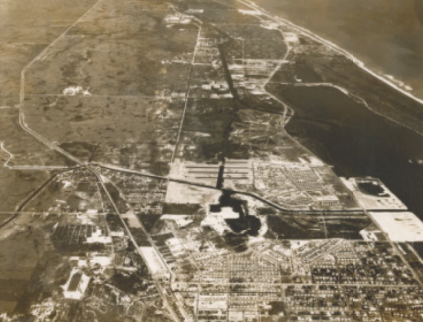
I copied this from the Palm Beach History web site…
| “From 1918 to 1923, in what is now Lake Park, there was an Earman Post Office. John Sites Earman was voted the first mayor of West Palm Beach when it was incorporated in 1894. Although he lived with his family in downtown West Palm Beach, Earman farmed north of town in the area that is now Lake Park and North Palm Beach. As preparation for the dredging of the Florida East Coast Canal in 1897, a ditch was dug south of the haulover from Lake Worth Creek in order to help drain the land for farming. Joseph Borman, before he became Palm Beach |
04/17/25 Update. You may recall that a section of this bridge in North Palm Beach fell into the canal.
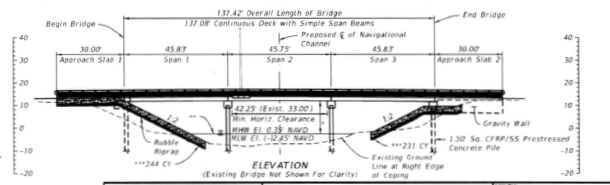
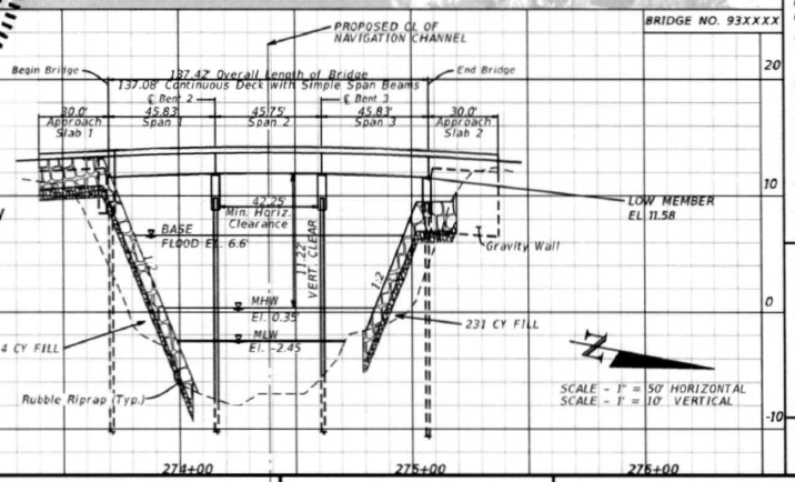
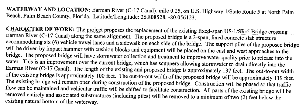
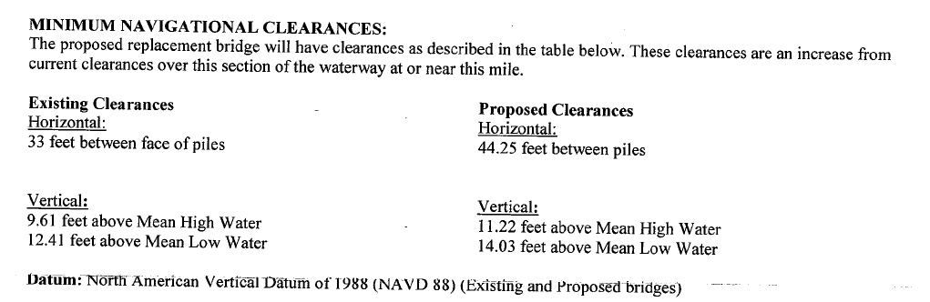
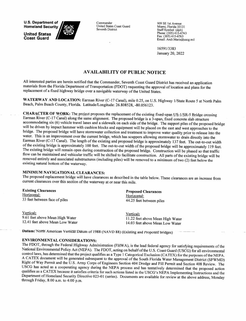
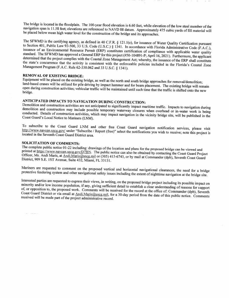
The plans for the bridge replacement are below but basically the bridge is being raised to 11.22 feet above Mean High Water from 9.61 feet, adding 1.61′. The existing canal bottom within the FDOT right of way is being dredged, which will happen after the bridge is demolished. The existing canal bottom is around elevation (-)8.44, and the new bottom will be at elevation (-)14.5, an additional depth of approximately 6’.
Florida DOT paid of the Schwenkee family for some sort of clarification on the right to go over the C-17 that the plans for to replace the US-1 bridge over the C-17 in North Palm Beach by Frigates is moving forward. I got a letter from the Coast Guard as sort of a notice to abutters. THE BRIDGE IS GOING TO REMAIN OPEN DURING CONSTRUCTION. The plans now have the ‘opening’ for a boat to get both wider by about 10′ and taller by about 1.61′ but honestly though, who knows. The CURRENT mean high water clearance of that bridge is a little under 8′. I go under every time I’m out in the boat and I drop my bimini so I can but I can reach over my head and touch the beam no problem. They are reporting that Bridge Clearance is NOW 9.61′ ABOVE MHW. Maybe to the bottom of the deck but not the beams holding it up. The section they provide below shows the ‘Low Member’ Elevation at +11.58 (NAVD) and the MHW at +0.35′. Call it 11′ clear at MHW under the new bridge or 3′ more clearance than the now +/-8′. Someone important must live behind that bridge.
OK, so I have done a few blog posts on the measured sea level rise at the LW Pier and how the mean high water is set by NOAA every 19 years. I found that time set odd. Not 15, not 20, but every 19 years. No mention of this on the NOAA site but apparently the moon orbit is not exact around the earth but ‘wobbles’ and does so on an 18.6 year cycle. WOW! I read all about this in Popular Mechanics article but it go me thinking. The article was based upon the research by a Professor that the University of Hawaii but he was educated in S. Florida…
https://www.soest.hawaii.edu/oceanography/faculty/Thompson.html
So, we have the effects of the gravity of the moon causing tides. And, as we know in South Florida we get floods during the ‘King Tides’. These are due to the moon being closer to the earth as certain times for certain places. Around here it happens to coincide with hurricane season in the fall. Apparently this distance not only varies throughout the year but also over a 18.6 year cycle. And the next cycle of higher high tides due to the proximity of the moon is to be in about 10 years. It’s time to get ready for those nuisance king tides to get even higher. Not even discussing climate change or sea level rise, this is a calculable astronomical effect. Just like we can tell you when the king tides will be.

Click HERE for the MLS data Coming Soon to Sea Colony! Desirable 3-bedroom, 3-bathroom home with a 2-car garage across from Jupiter Dog Beach. This big-dog-friendly residence features a single-family feel, soaring ceilings, and modern updates including a 2026 A/C system, impact windows, new appliances, luxury vinyl plank flooring, and porcelain tile bathrooms. Enjoy 24-hour manned security and resort-style amenities including pool, fitness center, tennis, […]

MLS Details Welcome to this spacious single family home located in Alton Neighborhood 1, Palm Beach Gardens. This lakefront residence offers 5 bedrooms, 4.5 bathrooms, and 4,236 square feet of finished living space across two thoughtfully designed levels. The flexible floor plan provides generous space for entertaining, working from home, hosting guests, or enjoying everyday living. A three-car garage offers ample room for vehicles, storage, […]

6130 SE Georgetown Place, Hobe Sound, FL 33455 […]