18079 Lake Bend Drive Jupiter, FL 33458
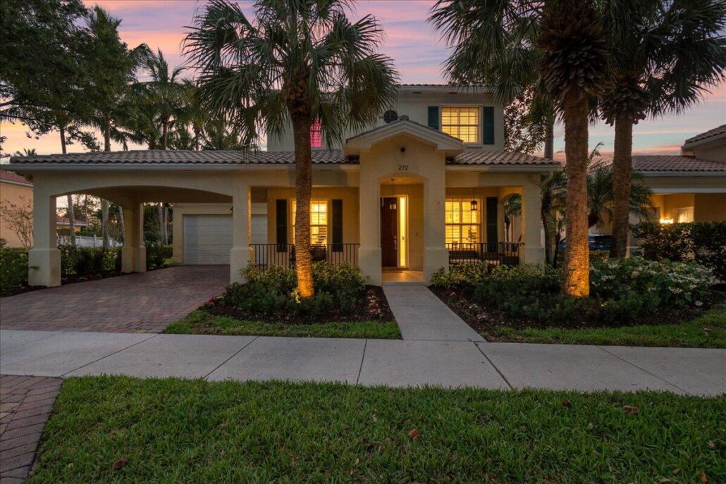
272 San Remo Drive Jupiter, FL 33458
272 San Remo Drive Jupiter, FL 33458 in Tuscany in Abacoa
This home is an entertainer’s paradise and a family’s dream come true. Furnished 5bed+den Tuscany home boasts luxurious features and open space throughout. The property sits on a preserve with an oversized private lot and a sparkling saltwater pool with waterfall, perfect for outdoor entertaining. Or, you can relax on the massive front porch overlooking the community green field. A gourmet kitchen, plantation shutters throughout, turf grass yard for you golfers, and custom lighting add to the luxurious feel of this home. The primary bedroom is conveniently located on the first floor, and the property boasts a 2-car garage with smart electric charging and 2-car Porte-Cochere.
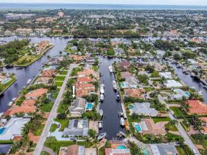
2442 Bay Circle Palm Beach Gardens, FL 33410
2442 Bay Circle Palm Beach Gardens, FL 33410 in Maheu Estates.
Spectacular waterfront lot in the heart of Palm Beach Gardens. Nice neighborhood and many newer homes. Many features include Serene & Peaceful wide water views w/SE breezes, deep water, no fixed bridges, overlooking million dollar homes,high elevation , NO HOA low county property taxes. Located 3mins away from garden mall , downtown at the gardens,lifetime gym,Whole Foods ,Publix, Trader Joe’s ,carmines gourmet market ,first class shopping and 94 restaurants on PGA Blvd. 20 mins to PB international airport. 25 minutes to palm beach island.only 3 MILES TO THE BREATHTAKING JUPITER,JUNO AND SINGER ISLAND BEACHES!.walk to Frenchmen’s forest nature trail. Next to may golf courses and country clubs with out side membership options. This is Florida living at its best !!. The owner has kept this 3 Bed, 2 Bath, 2 car garage CBS home in good condition .home offers tile floors, large lanai and updated kitchen w granite countertops. OR TEAR IT DOWN AND BUILD YOUR DREAM HOME ON THIS UNIGUE DEEP WATER HOMESITE. 130 ft x 71 ft wide on water, situated just a few lots from the intracoastal waterway.
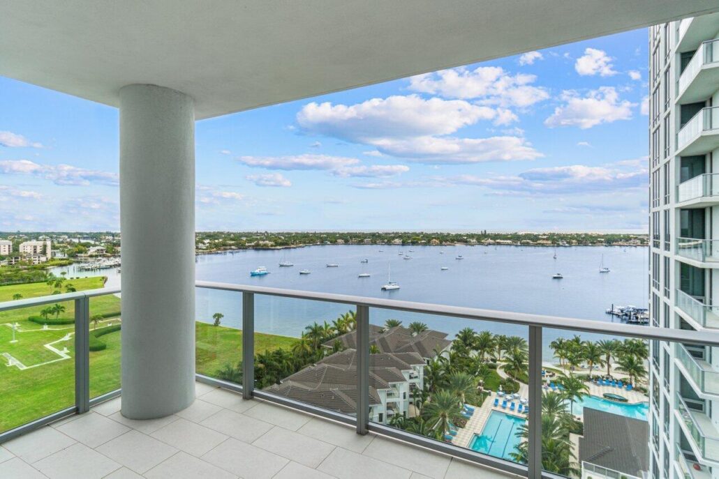
1 Water Club Way 1204-N North Palm Beach, FL 33408
1 Water Club Way 1204-N North Palm Beach, FL 33408 in The Water Club in North Palm Beach.
This contemporary 12th floor Water Club condo offers mesmerizing panoramic views of the intracoastal and ocean and a country club lifestyle without the headaches and fees. Located in a highly sought after pet-friendly building, 1 Water Club Way #1204 is the former Builder’s Model with upgraded appliances and custom closets. The open floor plan boasts views of the water from every room, floor-to-ceiling windows and doors, and two spacious terraces to enjoy the serene atmosphere and beautiful sunrises and sunsets. Enjoy unmatched, club-like amenities including a private elevator entrance to the spacious foyer, guest suites, three pools, two exercise rooms, pickle ball courts, 24-hour manned gated security.
How many people can live in a unit, condo, townhouse or house, in Palm Beach County?
How many is “too many” people to live in a housing unit, a condo, town house or house, in Palm Beach county?
First question is: Do the (if there are any) recorded documents or rules and regulation of the condo or HOA specify this? Many, but not all do.
Second is why is it Palm Beach County that we are asking the question for? Because the county code speaks to this. BUT be aware that there MAY also be local ordinance which can be more restrictive but not less restictive than the county ordinance. This is a link to code for Palm Beach County.
“Area for sleeping purposes. Every habitable room used for sleeping purposes by one (1) occupant shall contain at least seventy (70) square feet of floor area, and every room occupied for sleeping purposes by more than one (1) person shall contain at least fifty (50) square feet of floor area for each occupant thereof. Exception: Shelters, hospitals and similar uses shall be exempt.”
Note that the min dimension of a bedroom is 7′ and it must be 70 SF as per the above and it can NOT be a common room, like a living room as per “Prohibited occupancy. Kitchens, nonhabitable spaces and interior public areas shall not be used for sleeping purposes.” That it must have access to a bathroom “Water closet accessibility. Every bedroom shall have access to at least one (1) water closet and one (1) lavatory without passing through another bedroom.” and one must not HAVE to pass through another bedroom to get to it nor have to pass through a bedroom to get to other habitable space “Access from sleeping rooms. Sleeping rooms shall not constitute the only means of access to other sleeping rooms or habitable spaces.”
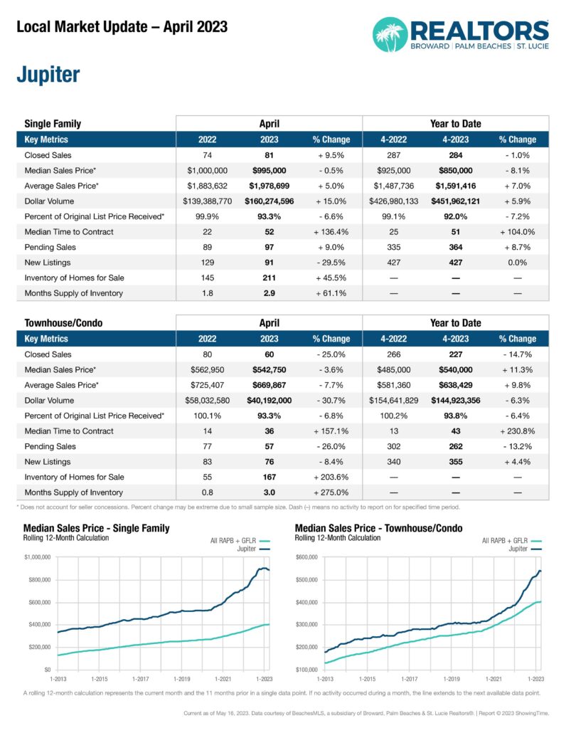
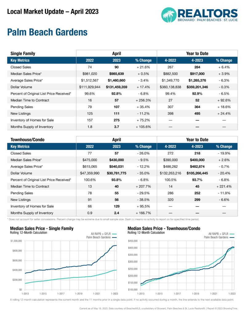
April 2023 Jupiter and Palm Beach Gardens housing market sales data
The local MLS just released the housing sales numbers for Jupiter and Palm Beach Gardens for the month of April 2023…
- « Previous Page
- 1
- …
- 31
- 32
- 33
- 34
- 35
- …
- 167
- Next Page »