I found this on a “self certification” permit and thought it was a good synopsis of what one can do with a dock configuration according to DEP. I did write a very long winded blog posting on the full rules and you can read that is you have the time and some coffee next to you.
How does the Community rating System Affect flood insurance premiums in Northern Palm Beach County
I started to look into this today and I was shocked. Before we get to that the CRS is basically a rating system for communities and how well they adhere to the National Flood Insurance community standards for things like building codes and flood plain management. If your community is great at it then you (the property Owner) get a % off your flood insurance premium. There’s a table for all the cities and towns and these are few in Northern Palm Beach County
Location | CRS | SFHA | NON SFHA | Status |
Palm Beach County | 5 | 25 | 10 | C |
Jupiter | 5 | 25 | 10 | C |
North Palm Beach | 7 | 15 | 5 | C |
Palm Beach Gardens | 10 | 0 | 0 | R |
Juno Beach | 5 | 25 | 10 | C |
Tequesta | 7 | 15 | 5 | C |
So, let’s say I live in the Village of North Palm Beach in a home built before the adoption of the FIRM panels which is to say it was built before 15 August 1978 for North Palm Beach. Since it is a pre-FIRM building then all flood zones qualify to the 15% discount.
If the property was built AFTER 15 August 1978 and is now in the SFHA Zone AE then the finished floor elevation must be equal to or greater than the Base Flood Elevation which is currently proposed to be 7′ (NAVD) in order to qualify for the discount.
The shocked part comes from 2 points. First, looking at the CRS for the various communities. Palm Beach Gardens homes get NO DISCOUNT and the R in the table stands for Rescinded. Those in the unincorporated PB County areas, Jupiter and Juno Beach get a 25% discount, while homes in Tequesta and North Palm Beach get a 15% discount. So a home such as 13958 Chester Bay in Frenchman Harbour will pay 10% less in flood insurance than those in say Harbour Isles . The second part is that the CRS discount does NOT apply to newly mapped policies.
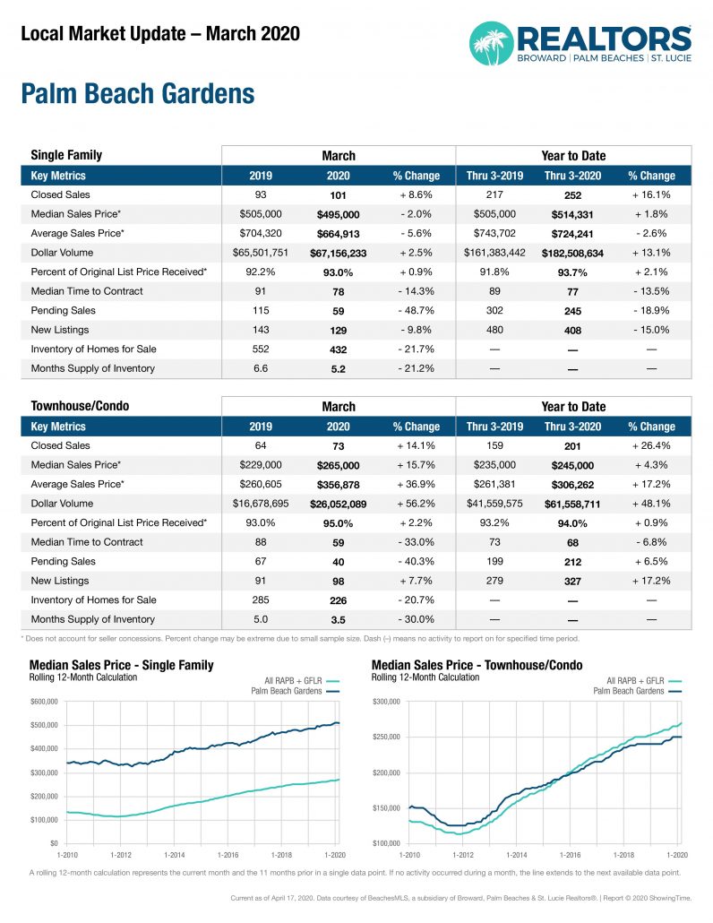
2019 Jupiter Palm Beach Gardens Housing Sales Numbers
The December 2019 housing sales were just released and we can now see the cumulative sales numbers for the year and the year over year changes.
Jupiter single family housing sales had a very respectable growth year with slightly more units (+2.1%) selling for a slightly higher median (+1.9%) and average (+1.8%) selling prices. Townhouse and condominium sales saw fewer units selling for a higher (+3.1%) sales price.
In Palm Beach Gardens we saw similar story for detached single family units with with slightly more units (+2.1%) selling for a slightly higher median (+4.7%) and average (+3.4%) selling prices. Townhouse and condominium sales saw more units sold (+1.8%) and a higher median price (+4.7%) sales price.
Flood Insurance and the Far/Bar As-IS Contract
What happens under the Far Bar As-Is (Rev 06/19) Contract if the Buyer can not obtain flood insurance?
PLEASE GO TO MY UPDATED BLOG POST FOR THE FAR BAR AS IS REVISED IN NOVEMBER 2021.
The applicable section of the Contract is:
First question: Is the Property located in a Special Flood Hazard Area (SFHA)? If it is NOT in an SFHA then this paragraph is not applicable. If it is in an SFHA (such as Zone AE or V) then the next questions is: “… the lowest floor elevation for the building(s) and/or flood insurance rating purposes is below minimum flood elevation or is ineligible for flood insurance coverage through the National Flood Insurance Program or private flood insurance as defined in 42 U.S.C. §4012a, Buyer may terminate this Contract…”
Honestly, this needs to be reworded on the first part “…and the lowest floor elevation for the building(s) and/or flood insurance rating purposes is below minimum flood elevation…” Is this to be interpreted that if the lowest floor elevation is below the Base Flood Elevation (BFE) set for the SFHA that the Buyer may withdraw? I’m looking into this.
The second part is straight forward. Is the finished floor elevation so low that the Property is in-eligible for coverage? This question as it turns out is specifically covered by the NFIP Flood Insurance Manual which states…
So basically all fixed houses (not a mobile home) which are built above grade (above the adjacent dirt, NOT the BFE) OR one which is NOT built above grade where the lowest level is above the Base Flood Elevation. In short, everyone CAN get flood insurance it’s just a question of cost. At least right now.
The interesting, and perplexing point here is that IF the house is shown inside the SFHA. Or if the SFHA even touches the property then the property owner may apply for a LOMR or Letter of Map Revision. I have done this. The criteria used for this is that the LAG or Lowest Adjacent Grade (the dirt around the house) must be higher than the Base Flood Elevation. “Federal regulations require the lowest ground touching the structure, or Lowest Adjacent Grade (LAG) elevation, to be at or above the Base Flood Elevation (BFE).” Looking at the rate tables the big “jump” in the rate per dollar of insured value (the cost) of flood insurance comes when the finished floor is less than 1′ above the Base Flood Elevation.
What I would recommend doing is IF a home is located in an area where flood insurance is now required then I would use the Homeowners/Flood Insurance addendum to the Far/Bar contract which add this:
Note that the areas which are located inside a Coastal Barrier Resource Act area are basically ALL existing parks like MacArthur, Carlin, Blowing Rocks and the Hobe Sound National Wildlife Sanctuary. So basically, no place that anyone lives around here.
How much have the flood zones changed around Jupiter?
FEMA just released the proposed FIRM Maps in December of 2019 for Florida and Palm Beach County. CLICK HERE to read my post on the new maps. This got me thinking though. In terms of elevations using the same base line just how much have the flood zones changed?
For this example I am going to look at the community of Frenchmans Harbor in Juno Beach at the base of the Donald Ross bridge. So, let’s go to the the FEMA Map center and look up my listing at 13958 Chester Bay Lane.
The current (as of Jan 2020) flood zone map does NOT show this property as being in the Special Flood Hazard Area Zone AE. However the zone AE is in the area and the Base Flood Elevation is given there as +4′ by the 1988 NAVD datum.
From the survey accompanying the boat lift permit, the elevation at the top of the sea wall is 7.3’ (1929) and the Finished Floor Elevation of the house is at 9.22’ (1929). Converting these to the 1988 datum we have the top of sea wall is at 7.3’-1.54’ = 5.76’ (1988) and the FF El. = 9.22’-1.54’ = 7.68’ (1988).
So we see that the current base flood elevation (4′) is BELOW the top of the sea wall at 5.76′. But what was the Base Flood Elevation before the last map change was adopted in October of 2017?
Frenchmans Harbor is in unincorporated Palm Beach County. The first FIRM Maps for Palm Beach County were effective as of 02/01/1979. Prior to the most recent (curent) map the last revision was effective on 10/15/1982. This map gave the Base Floor Elevation of Zone A, which was in the SFHA, as 6′ by the 1929 NGVD datum. A BFE of 6′ by the 1929 datum is 4.46′ by the 1988 NAVD datum.
So, from 1982 to 2017 the Base Flood Elevation was 4.46′. Then, in 2017 it was changed to 4′, so it went down in real terms. Now they want to raise the Base Flood Elevation by 3′ from a BFE=4′ to a BFE = 7′.
The proposed flood map is for the BFE = 7’ for 13958 Chester Bay BUT the AE zone does not touch the property. It does show the shaded zone X as being in the back yard. I looked at the old survey for the property and the FF El is 9.22′ by the 1929 datum and thus is FF El. = 7.68’ (1988 NAVD). With the finished floor elevation (FF El. = 7.68’) being above the BFE of 7′ it should not be rated as being in a SFHA.
Frenchmans Harbor is in the new Flood Zone
OK, So I always thought that the top of the sea wall for the houses in Frenchmans Harbor was far above the water and as it turns out it is.
The new proposed flood maps were just released at the end of 2019 and in the middle of a whole bunch of waterfront losers there is the winner of Frenchmans Harbor in Juno Beach where the house such as the one at 13958 Chester Bay Lane are still NOT in the flood zone.
Today, 02/05/2000, I was down at the Flood Zone Explanation, open house put on by FEMA and in speaking to the engineers there I determined why this map is showing data that is clearly wrong. Get ready for it. The FEMA Maps for this area are based upon an aerial LIDAR survey done in 2007. WOW! Palm Beach County paid for a new aerial survey but that was not completed in time for use on the new maps.
- « Previous Page
- 1
- …
- 67
- 68
- 69
- 70
- 71
- …
- 144
- Next Page »