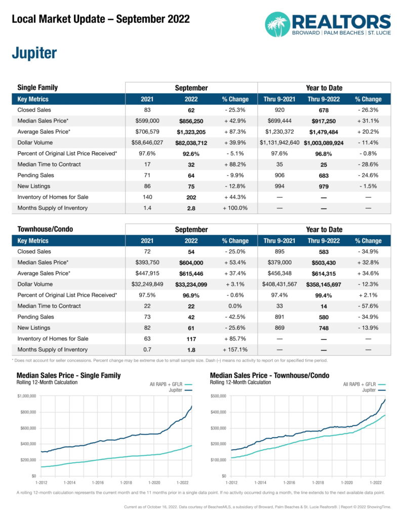
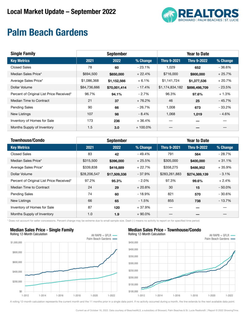
Some interesting numbers this month which show what I already know. THERE’S NO INVENTORY. Look at the number of Closed Sales and the dollar volume and note the dramatic difference between this time last year compare to now. Both are down dramatically and this reflects the simple lack of inventory.
Juno Beach Artfest 2022
The Juno Beach Artfest by the Sea returns this weekend March 12th and 13th from 10 AM to 5 PM on Ocean Blvd from Donald Ross Rd north to Marcinki. Stop by the office across the street in the Plaza La Mer at 865 Donald Ross Rd and pick up one of our free maps of the area, maybe even grab a gelato next door at Mattie’s or a bite to eat at one of the restaurants in the Plaza. Technically speaking you are supposed to park at FP&L (700 Universe Blvd, Juno Beach, FL 33408) and bus yourself in but folks do sometimes park here. Please just do NOT park right in front of our businesses. Those are for customers.
Dates and Community Rating System Discounts for Palm Beach County
The “Public Trust” doctrine for navigable waters in Florida.
I read a VERY INTERESTING article today and I leaned something new. I have written about about the meander line and how that is shown on plats in Jupiter area. I also write about the troubles around this shown when perhaps not applicable along the C-17 a/k/a Earman River in North Palm Beach.
What I learned is that there are 2 types of land “owned’ by the state. The first is land which they acquired as a result of being granted statehood. This is what is called sovereign lands and was to be held in public trust. Sovereign, as in the Kings Land. Wait what? The original 13 colonies got, when we won the war for independance, the land below navigable waters as this was owned by the sovereign (the king) so subsequent states got this land too as the had to be on “equal footing” with the origioanl 13. Sovereign land is the lands below “navigable rivers, lakes, and tidelands are held in a public trust which imposes a legal duty upon the state to preserve and control them for public navigation, fishing, swimming, and other lawful uses.” The courts in Florida have upheld that even is one has a deed conveying these lands that the state had no right to sell it. WOW!
The second type of land the state acquired title to NOT as a result of simply becoming a state but lands which the Federal government GAVE to them by Act(s) of Congress with the INTENTION of being sold to, and utilized by, private citizens. I have written of how this land was used to create what would become the intracoastal waterway in the area. This is what is called “improvements lands”. These lands were sold to, or traded to, developers as payment for the creation of say a mile of canal, roadway or of a railroad.
In “1855 Florida Legislature created the Internal Improvement Fund, which consisted of title to internal improvement lands and swamp lands and all proceeds from the sale of such lands. The legislature then vested title to the internal improvement lands and swamp lands in the “Trustees of the Internal Improvement Fund” (the governor and cabinet) and gave them authority to sell and transfer the lands as prescribed by statute.”
History of the Earman River
OK, so perhaps you have read my blog posting on the what is called the Earman River and the issues with North Palm Beach Properties. In fact though, the “earman River” is NOT a river. It never was a river. It’s the C-17 canal managed by the South Florida Water Management District. Why do we call it the Earman River? I thought we had picked it up as a marketing name from the the developer of North Palm Beach. No one would pay more to live on the ‘C-17 Canal’ but the ‘Earman River’, that sounds VERY nice, someone just might pay me extra $$ to live on that. But as usual that’s about 1/2 the story.
Way back when the state of Florida was granted statehood, what we today call Lake Worth was an actual fresh water lake. On the west bank ONE WOULD ASSUME there was a small creek around where the C-17 is. Basic laws of human action are that we take the ath of least resistance whenever possible. Why do more work than we have to. So I would assume there was something there but perhaps not. I found this survey of the area done in 1859 and it clearly does NOT show any inlets or rivers. Thus it’s appears safe to say that the C-17 canal was not navigable in 1845 when florida entered the union as it was not “meandered” in 1859. Earman was the guy who farmed that area in the early 1900’s. Story is that he and a few other guys dug out this ( I assume) already low lying creek to drain the adjacent land for farming. It was “officially named for Earman after his death in 1932” according to a PB Post article anyway. But to be clear it was NEVER a river and we really should stop calling it that as it’s the farthest thing from it. Not only is it overflowed lands BUT the SFWMD controls it and they can dredge it anytime they want without much regard for permits. This is an aerial image from 1958, and it is very clearly a man made canal. Thus, adjacent property owners would not enjoy “Riparian Rights“.
I copied this from the Palm Beach History web site…
“From 1918 to 1923, in what is now Lake Park, there was an Earman Post Office. John Sites Earman was voted the first mayor of West Palm Beach when it was incorporated in 1894. Although he lived with his family in downtown West Palm Beach, Earman farmed north of town in the area that is now Lake Park and North Palm Beach. As preparation for the dredging of the Florida East Coast Canal in 1897, a ditch was dug south of the haulover from Lake Worth Creek in order to help drain the land for farming. Joseph Borman, before he became Palm Beach |
US-1 Bridge Replacement over Earman River / C-17
02/16/2023 – UPDATE – The FDOT page (no longer up 11/30/24) had this project (4428912) set to begin in the spring of 2023 and it was to be completed by the summer of 2024. They did NOT call for a full closure of this bridge. You may recall that a section of this bridge in North Palm Beach fell into the canal.
Then, as I understand it, the governor prioritized some propjects thoughout the state but NOT this one which stoped just after they laid out the road cones. The FDOT shows the 14.5M for this project as having been rolled forward in 2025 and being in the CST or construction phase.
Florida DOT paid of the Schwenkee family for some sort of clarification on the right to go over the C-17 that the plans for to replace the US-1 bridge over the C-17 in North Palm Beach by Frigates is moving forward. I got a letter from the Coast Guard as sort of a notice to abutters. THE BRIDGE IS GOING TO REMAIN OPEN DURING CONSTRUCTION. The plans now have the ‘opening’ for a boat to get both wider by about 10′ and taller by about 1.61′ but honestly though, who knows. The CURRENT mean high water clearance of that bridge is a little under 8′. I go under every time I’m out in the boat and I drop my bimini so I can but I can reach over my head and touch the beam no problem. They are reporting that Bridge Clearance is NOW 9.61′ ABOVE MHW. Maybe to the bottom of the deck but not the beams holding it up. The section they provide below shows the ‘Low Member’ Elevation at +11.58 (NAVD) and the MHW at +0.35′. Call it 11′ clear at MHW under the new bridge or 3′ more clearance than the now +/-8′. Someone important must live behind that bridge.
- « Previous Page
- 1
- …
- 41
- 42
- 43
- 44
- 45
- …
- 144
- Next Page »