What happens when a true riparian uplands lot owner has fill between the meander line shown on the plat and where the current bulkhead or sea wall exists? So, the sea wall is waterward of the historic high water mark. Well, if the sea wall was there in 1975 then state has agreed to abandon their claim of ownership interest in that land. WOW! FREE LAND!
The section of the statute is below and before we get into an example of this I had in a listing I just sold at 14208 Harbor Lane in Palm Beach Gardens it is worth noting that although commonly referred to as the ‘Bulkhead Act’ the language does not require a bulkhead but only that: ” transfer title only to so much of such extended or added land as was permanently exposed, extended, or added to before July 1, 1975.”
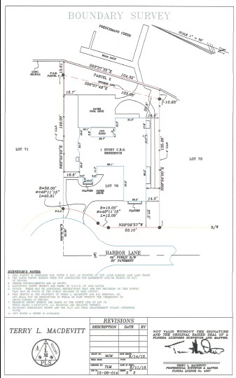
So, let’s look at an example and in this post I show what a lot of land looks like on a plat when the uplands enjoys riparian rights. When the lot boundary on the water side is properly shown, that boundary, represented by the meander line, can and does move. It is said to be ambulatory. It does not necessarily show where historic high water line is only that it’s someplace around there. For these 2 reasons the plat shows +/- dimensions for the length of the property lines intersecting the meander line. What the language of this section of Florida statute does is address the issue of dry land added before 1975 that is now seaward of the meander line. The state basically says that if the fill was there in (now) 1975 then the uplands lot can add this land to their lot. For the house noted above when they bought the house they had a surveyor locate the seawall and they got title insurance on that extra bit of land. This is noted as Parcel 2 on the following survey…

FS 253.12(9) All of the states right, title, and interest to all tidally influenced land or tidally influenced islands bordering or being on sovereignty land, which have been permanently extended, filled, added to existing lands, or created before July 1, 1975, by fill, and might be owned by the state, is hereby granted to the landowner having record or other title to all or a portion thereof or to the lands immediately upland thereof and its successors in interest. Thereafter, such lands shall be considered private property, and the state, its political subdivisions, agencies, and all persons claiming by, through, or under any of them, shall be barred from asserting that any such lands are publicly owned sovereignty lands. The foregoing provisions shall act to transfer title only to so much of such extended or added land as was permanently exposed, extended, or added to before July 1, 1975. A showing of dates by which certain lands were filled or added to may be made by aerial photograph or other reasonable method. Upon request of the landowner and submission of a proposed legal description and aerial photographs or other evidence accompanied by a fee set by the board reflecting the actual administrative cost of processing, the board shall provide an appropriate legal description of the waterward boundary line as of July 1, 1975, in a recordable document. The Legislature specifically finds and declares these grants to be in the public interest. The boundary between state-owned sovereignty lands and privately owned uplands is ambulatory and will move as a result of nonavulsive changes. This subsection shall not grant or vest title to any filled, formerly submerged state-owned lands in any person who, as of January 1, 1993, is the record titleholder of the filled or adjacent upland property and who filled or caused to be filled the state-owned lands.


